 vesseltracker.com
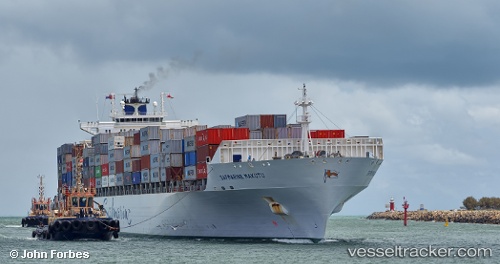
Safmarine Makutu
Current StatusWhere is the vessel?
Safmarine Makutu is currently in Near SUEZ CANAL, based on AIS data received about 1h ago.
Latest AIS update:
Current position: 30.31203° N, 32.41058° E (Near SUEZ CANAL)
Average speed (last 7 days): Loading…
Average speed (last 30 days): Loading…
Vessel profile: Safmarine Makutu is a Container Ship with dimensions 32m x 292m.
This page combines live AIS, route history, probable destination signals, nearby traffic, and port activity for practical vessel monitoring.
The current position of vessel Safmarine Makutu is 30.31203 lat / 32.41058 lng. Updated: 2026-04-07 10:06:00 UTCNearest reference points:
- Near SUEZ CANAL
- Near As Suways (Suez)
- Near SUEZ PORT
Details:
Live Vessel Safmarine Makutu Analytics (details, animations, etc.)
Recent AIS points (UTC):
2026-04-07 04:00:00 UTC · 31.20465, 32.33877 · SOG 6.3 kn · COG 193°2026-04-07 05:46:39 UTC · 30.94631, 32.31319 · SOG 8.6 kn · COG 179°
2026-04-07 07:34:07 UTC · 30.68143, 32.33940 · SOG 8.7 kn · COG 192°
2026-04-07 10:06:00 UTC · 30.31203, 32.41058 · SOG 10.1 kn · COG 143°