 vesseltracker.com
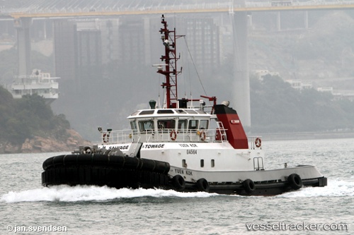
 SHA TIN
Current Status
Where is the vessel?
SHA TIN is currently in Near Ting Kau, based on AIS data received less than 1h ago.
Latest AIS update:
Current position: 22.36652° N, 114.09999° E (Near Ting Kau)
Average speed (last 7 days): Loading…
Average speed (last 30 days): Loading…
Vessel profile: SHA TIN is a Tug with dimensions 29m x 11m.
This page combines live AIS, route history, probable destination signals, nearby traffic, and port activity for practical vessel monitoring.
The current position of vessel SHA TIN is 22.36652 lat / 114.09999 lng. Updated: 2026-04-17 00:00:34 UTCNearest reference points:
- Near Ting Kau
- Near Tsing Yi
- Near Lai Chi Kok
Currently sailing under the flag of Hong Kong, China ![]()
SHA TIN built in 2005 year
Deadweight:
178 tDetails:
Live Vessel SHA TIN Analytics (details, animations, etc.)
Recent AIS points (UTC):
2026-04-16 17:24:12 UTC · 22.34363, 114.11363 · SOG 0.1 kn · COG -1°2026-04-16 19:47:02 UTC · 22.34367, 114.11361 · SOG 0 kn · COG -1°
2026-04-16 21:26:14 UTC · 22.32644, 114.12717 · SOG 1.3 kn · COG -1°
2026-04-17 00:00:34 UTC · 22.36652, 114.09999 · SOG 0.2 kn · COG -1°