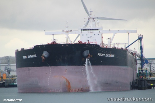
.
Vessel photo of Front Kathrine (IMO 9384590) vesseltracker.com

MH flag Front Kathrine

Vessel type: Crude Oil Tanker | IMO: 9384590 | MMSI: MMSI: 538003455
Call sign: V7QX2 | Dimensions: 330 m x 60 m
Current Status

Where is the vessel?

Front Kathrine is currently in 156 nm E of Tamatave, based on AIS data received about 2h ago.

Latest AIS update:

Current position: 17.60718° S, 52.09205° E (156 nm E of Tamatave)

Average speed (last 7 days): Loading…

Average speed (last 30 days): Loading…

Vessel profile: Front Kathrine is a Crude Oil Tanker with dimensions 330m x 60m.

This page combines live AIS, route history, probable destination signals, nearby traffic, and port activity for practical vessel monitoring.

The current position of vessel Front Kathrine is -17.60718 lat / 52.09205 lng. Updated: 2026-04-02 09:22:57 UTC
Nearest reference points:
  • 183 nm E of Tamatave
  • 210 nm NE of Tamatave

Currently sailing under the flag of Marshall Is MH flag

Front Kathrine built in 2009 year

Deadweight:
297974 t

Details:

Live Vessel Front Kathrine Analytics (details, animations, etc.)


Recent AIS points (UTC):
2026-04-02 04:11:02 UTC · -16.50433, 52.67443 · SOG 13.8 kn · COG 205°
2026-04-02 06:03:58 UTC · -16.89833, 52.46833 · SOG 14 kn · COG -1°
2026-04-02 08:09:57 UTC · -17.34667, 52.23000 · SOG 14 kn · COG -1°
2026-04-02 09:22:57 UTC · -17.60718, 52.09205 · SOG 14.6 kn · COG 205°

Track of the vessel in the last 60 days


UTC: --
Start: -- Track timeline (UTC) End: --
Encountered: --


Link to the map:


Find another ship

Front_Kathrine (538003455) last ports (portcalls and passsages)

BUKOM ISLAND | 2025-08-28 05:25:38
Singapore | 2025-08-25 20:44:54
PULAU SAMBU | 2025-08-25 19:54:35
BATU AMPAR | 2025-08-25 18:54:00
BUKOM ISLAND | 2025-08-23 02:19:36
JURONG ISLAND | 2025-08-23 01:07:28
Fujairah | 2025-08-08 00:37:25
PULAU SAMBU | 2025-07-26 15:49:11
BATU AMPAR | 2025-07-26 15:02:58
TANAH MERAH | 2025-07-24 05:07:14
PENGERANG | 2025-07-24 04:19:58
PENGERANG | 2025-07-07 11:55:18
TANAH MERAH | 2025-07-07 11:01:55
BUKOM ISLAND | 2025-07-07 09:24:19
ASALUYEH | 2025-06-23 07:05:11
Assaluyeh | 2025-06-22 08:26:54
GANGAVARAM | 2025-05-14 18:43:40
Forcados Offshore Terminal | 2025-04-13 06:41:35
Forcados Offshore Terminal | 2025-04-09 05:58:51
Cape Lopez | 2025-04-05 02:58:57
Port Louis | 2025-03-19 08:46:01
JURONG ISLAND | 2025-02-19 02:39:41
PULAU SAMBU | 2025-02-19 01:22:48
TANAH MERAH | 2025-02-15 03:25:34
PENGERANG | 2025-02-15 01:52:04
TANAH MERAH | 2025-01-26 02:57:21
BATU AMPAR | 2025-01-26 02:18:46
BUKOM ISLAND | 2025-01-26 01:25:00
Ras Tannurah | 2025-01-09 22:31:44
JURONG ISLAND | 2024-12-25 20:18:34
PULAU SAMBU | 2024-12-25 18:56:58
TANAH MERAH | 2024-12-25 18:08:08
PENGERANG | 2024-12-25 17:15:56
TANAH MERAH | 2024-12-07 03:03:18
PENGERANG | 2024-12-07 01:28:28
Kaohsiung | 2024-12-01 06:39:40
LINKOU | 2024-11-29 01:35:05
PENGERANG | 2024-11-06 16:01:33
PULAU SAMBU | 2024-11-05 21:43:58
BUKOM ISLAND | 2024-11-05 20:34:53
Vlaardingen | 2024-08-09 03:17:43
Maassluis | 2024-08-09 00:35:04
Vlaardingen | 2024-08-05 02:11:43
Maassluis | 2024-08-05 00:30:14
Mosselbay | 2024-07-12 07:12:31
Sirri Island | 2024-06-20 04:07:35
Az Zarqa Island | 2024-06-16 05:54:38
Singapore | 2024-06-04 17:28:55
Yosu | 2024-04-10 06:59:26
Yosu | 2024-04-04 06:59:25
Yosu | 2024-03-31 06:57:59
Sambu | 2024-03-08 03:00:39
Sambu | 2024-02-01 23:43:56
Singapore | 2023-11-30 07:40:24
Singapore | 2023-09-21 06:34:42
Cape Lopez | 2023-08-16 21:56:09
Cape Lopez | 2023-08-12 21:35:07
Singapore | 2023-07-10 14:26:44
Singapore | 2023-05-21 17:03:11
Sambu | 2023-05-02 15:32:22
Das Island | 2023-04-20 03:44:47
Az Zarqa Island | 2023-04-17 11:46:46
Sirri Island | 2023-04-17 00:05:31
Fujairah | 2023-01-02 06:05:40
Singapore | 2022-11-03 20:16:30
Ta-Ku | 2022-10-21 10:36:05
Taku Bar | 2022-10-21 07:39:19
Singapore | 2022-10-03 04:29:51
Kribi | 2022-08-30 04:34:06
Singapore | 2022-07-04 19:16:17
Sirri Island | 2022-06-21 22:46:46
Singapore | 2022-05-20 01:24:03
Sambu | 2022-05-20 01:12:20
Singapore | 2022-03-04 12:25:56
Singapore | 2022-02-02 16:45:33