 vesseltracker.com
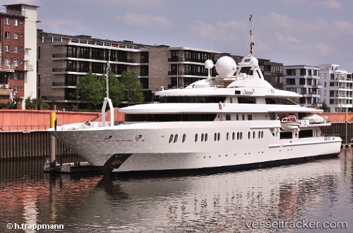
Vessel Queen Miri IMO: 9288203, MMSI: 538071066 Service Ship
UTC, 18.01834, -63.04574, course: 338, speed: 0
UTC, 18.01834, -63.04574, course: 338, speed: 0
2026-03-04 14:29:58 UTC, 18.01836, -63.04574, course: 338, speed: 0
Live Vessel Queen Miri Analytics (details, animations, etc.)
Live AIS position: UTC. Near PHILIPSBURG), updated 2026-03-04 14:29:58 UTC.Find the position of the vessel Queen Miri on the map. The latter are known coordinates and path.
marine traffic ship tracker show on live map
The current position of vessel Queen Miri is 18.01836 lat / -63.04574 lng. Updated: 2026-03-04 14:29:58 UTCCurrently sailing under the flag of Marshall Is
Queen Miri built in 2004 year
Deadweight:
600 tDetails:
Last coordinates of the vessel:
UTC, 18.01834, -63.04575, course: 338, speed: 0UTC, 18.01834, -63.04574, course: 338, speed: 0
UTC, 18.01834, -63.04574, course: 338, speed: 0
2026-03-04 14:29:58 UTC, 18.01836, -63.04574, course: 338, speed: 0