 vesseltracker.com
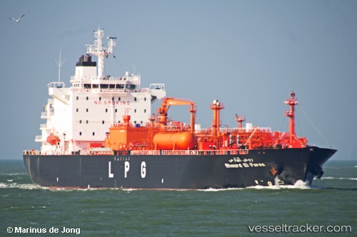
Vessel Rhourd El Fares IMO: 9537044, MMSI: 605076052 Lpg Tanker
UTC, 35.81557, -0.24539, course: 190, speed: 0
UTC, 35.81555, -0.24538, course: 190, speed: 0
2026-01-15 05:36:14 UTC, 35.81551, -0.24538, course: 190, speed: 0
Live AIS position:
UTC. Near Bettioua),
updated 2026-01-15 05:36:14 UTC.
Find the position of the vessel Rhourd El Fares on the map. The latter are known coordinates and path.
marine traffic ship tracker show on live map
The current position of vessel Rhourd El Fares is 35.81551 lat / -0.24538 lng. Updated: 2026-01-15 05:36:14 UTCCurrently sailing under the flag of Algeria
Rhourd El Fares built in 2010 year
Deadweight:
27353 tDetails:
Last coordinates of the vessel:
UTC, 35.81557, -0.24539, course: 190, speed: 0UTC, 35.81557, -0.24539, course: 190, speed: 0
UTC, 35.81555, -0.24538, course: 190, speed: 0
2026-01-15 05:36:14 UTC, 35.81551, -0.24538, course: 190, speed: 0