 vesseltracker.com
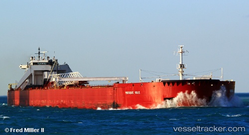
 PRESQUE ISLE
Current Status
Where is the vessel?
PRESQUE ISLE is currently in 33 nm SE of Ossineke, based on AIS data received less than 1h ago.
Latest AIS update:
Current position: 44.60333° N, 82.78833° W (33 nm SE of Ossineke)
Average speed (last 7 days): Loading…
Average speed (last 30 days): Loading…
Vessel profile: PRESQUE ISLE is a Articulated Pusher Tug with dimensions m x m.
This page combines live AIS, route history, probable destination signals, nearby traffic, and port activity for practical vessel monitoring.
The current position of vessel PRESQUE ISLE is 44.60333 lat / -82.78833 lng. Updated: 2026-04-09 18:00:33 UTCNearest reference points:
- Near Meldrum
- Near Fort Gratiot
- Near Saint Clair Shores
Currently sailing under the flag of United States ![]()
Details:
Live Vessel PRESQUE ISLE Analytics (details, animations, etc.)
Recent AIS points (UTC):
2026-04-09 12:02:37 UTC · 45.66817, -83.56269 · SOG 12.1 kn · COG 142°2026-04-09 13:42:33 UTC · 45.39833, -83.27167 · SOG 12 kn · COG -1°
2026-04-09 16:21:33 UTC · 44.92167, -82.94500 · SOG 12 kn · COG -1°
2026-04-09 18:00:33 UTC · 44.60333, -82.78833 · SOG 12 kn · COG -1°