 vesseltracker.com
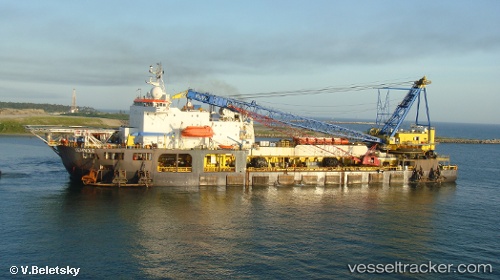
 Seminole
Current Status
Where is the vessel?
Seminole is currently in 12 nm SE of Brass River, based on AIS data received about 6h ago.
Latest AIS update:
Current position: 3.88500° N, 6.36500° E (12 nm SE of Brass River)
Average speed (last 7 days): Loading…
Average speed (last 30 days): Loading…
Vessel profile: Seminole is a Pipe Layer with dimensions 135m x 30m.
This page combines live AIS, route history, probable destination signals, nearby traffic, and port activity for practical vessel monitoring.
The current position of vessel Seminole is 3.88500 lat / 6.36500 lng. Updated: 2026-04-10 06:58:04 UTCNearest reference points:
- 12 nm N of Okwori
- 21 nm SW of Bonny
- Near Bonny
Currently sailing under the flag of Italy ![]()
Seminole built in 1975 year
Deadweight:
10969 tDetails:
Live Vessel Seminole Analytics (details, animations, etc.)
Recent AIS points (UTC):
2026-04-10 02:25:03 UTC · 3.88500, 6.36500 · SOG 0 kn · COG -1°2026-04-10 03:46:00 UTC · 3.88500, 6.36500 · SOG 0 kn · COG -1°
2026-04-10 05:46:03 UTC · 3.88500, 6.36500 · SOG 0 kn · COG -1°
2026-04-10 06:58:04 UTC · 3.88500, 6.36500 · SOG 0 kn · COG -1°