 vesseltracker.com
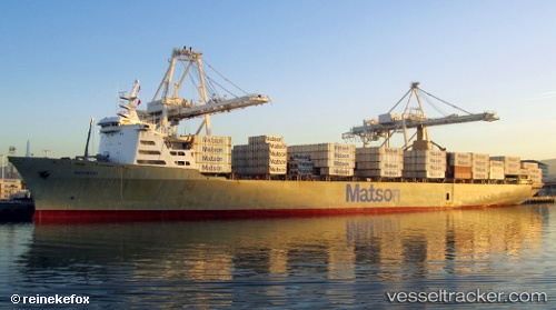
 Mahimahi
Current Status
Where is the vessel?
Mahimahi is currently in Near Honolulu, based on AIS data received about 1h ago.
Latest AIS update:
Current position: 21.31196° N, 157.87791° W (Near Honolulu)
Average speed (last 7 days): Loading…
Average speed (last 30 days): Loading…
Vessel profile: Mahimahi is a Container Ship with dimensions 262m x 32m.
This page combines live AIS, route history, probable destination signals, nearby traffic, and port activity for practical vessel monitoring.
The current position of vessel Mahimahi is 21.31196 lat / -157.87791 lng. Updated: 2026-04-03 19:25:10 UTCNearest reference points:
- Near Honolulu
- Near Kaunakakai
- 132 nm SW of Barbers Point
Currently sailing under the flag of USA ![]()
Mahimahi built in 1983 year
Deadweight:
35149 tDetails:
Live Vessel Mahimahi Analytics (details, animations, etc.)
Recent AIS points (UTC):
2026-04-03 14:10:14 UTC · 21.31194, -157.87791 · SOG 0 kn · COG 124°2026-04-03 16:10:26 UTC · 21.31196, -157.87791 · SOG 0 kn · COG -1°
2026-04-03 17:37:15 UTC · 21.31201, -157.87794 · SOG 0 kn · COG 123°
2026-04-03 19:25:10 UTC · 21.31196, -157.87791 · SOG 0 kn · COG 123°