 vesseltracker.com
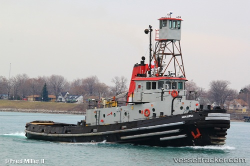
Nickelena
Current StatusWhere is the vessel?
Nickelena is currently in 12 nm NE of Brussels, based on AIS data received about 3d ago.
Latest AIS update:
Current position: 44.83796° N, 87.38311° W (12 nm NE of Brussels)
Average speed (last 7 days): Loading…
Average speed (last 30 days): Loading…
Vessel profile: Nickelena is a Tug with dimensions 8m x 33m.
This page combines live AIS, route history, probable destination signals, nearby traffic, and port activity for practical vessel monitoring.
The current position of vessel Nickelena is 44.83796 lat / -87.38311 lng. Updated: 2026-03-23 19:03:17 UTCNearest reference points:
- 12 nm NE of Brussels
- Near Pentwater
- Near MILWAUKEE
Details:
Live Vessel Nickelena Analytics (details, animations, etc.)
Recent AIS points (UTC):
2026-03-23 18:21:12 UTC · 44.84399, -87.38739 · SOG 0.5 kn · COG -1°2026-03-23 19:03:17 UTC · 44.83796, -87.38311 · SOG 0 kn · COG -1°
2026-03-23 19:03:17 UTC · 44.83796, -87.38311 · SOG 0 kn · COG -1°
2026-03-23 19:03:17 UTC · 44.83796, -87.38311 · SOG 0 kn · COG -1°