 vesseltracker.com
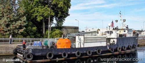
 Nrc Cape Flattery
Current Status
Where is the vessel?
Nrc Cape Flattery is currently in Near Neah Bay, based on AIS data received about 81d ago.
Latest AIS update:
Current position: 48.36709° N, 124.61246° W (Near Neah Bay)
Average speed (last 7 days): Loading…
Average speed (last 30 days): Loading…
Vessel profile: Nrc Cape Flattery is a Pollution Control Vessel with dimensions 35m x 8m.
This page combines live AIS, route history, probable destination signals, nearby traffic, and port activity for practical vessel monitoring.
The current position of vessel Nrc Cape Flattery is 48.36709 lat / -124.61246 lng. Updated: 2026-01-06 18:43:43 UTCNearest reference points:
- Near Clallam Bay
- 21 nm NW of Tatoosh Island
- Near Cassidy
Currently sailing under the flag of USA ![]()
Details:
Live Vessel Nrc Cape Flattery Analytics (details, animations, etc.)
Recent AIS points (UTC):
2026-01-06 18:43:43 UTC · 48.36709, -124.61246 · SOG 0.1 kn · COG 342°