 vesseltracker.com
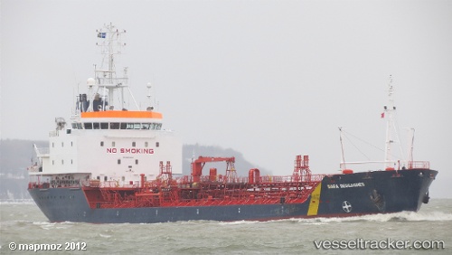
 CARIBBEAN ENERGY
Current Status
Where is the vessel?
CARIBBEAN ENERGY is currently in Near Lyford Cay, based on AIS data received less than 1h ago.
Latest AIS update:
Current position: 24.96129° N, 77.52263° W (Near Lyford Cay)
Average speed (last 7 days): Loading…
Average speed (last 30 days): Loading…
Vessel profile: CARIBBEAN ENERGY is a Chemical/Oil Products Tanker with dimensions 124m x 18m.
This page combines live AIS, route history, probable destination signals, nearby traffic, and port activity for practical vessel monitoring.
The current position of vessel CARIBBEAN ENERGY is 24.96129 lat / -77.52263 lng. Updated: 2026-04-01 21:40:33 UTCNearest reference points:
- Near Lyford Cay
- 11 nm S of Lyford Cay
- Near Nassau
Currently sailing under the flag of Mongolia ![]()
CARIBBEAN ENERGY built in 1992 year
Deadweight:
10511 tDetails:
Live Vessel CARIBBEAN ENERGY Analytics (details, animations, etc.)
Recent AIS points (UTC):
2026-04-01 16:06:16 UTC · 24.96149, -77.52259 · SOG 0 kn · COG -1°2026-04-01 18:19:18 UTC · 24.96168, -77.52254 · SOG 0 kn · COG -1°
2026-04-01 19:55:26 UTC · 24.96168, -77.52261 · SOG 0 kn · COG -1°
2026-04-01 21:40:33 UTC · 24.96129, -77.52263 · SOG 0 kn · COG -1°