 vesseltracker.com
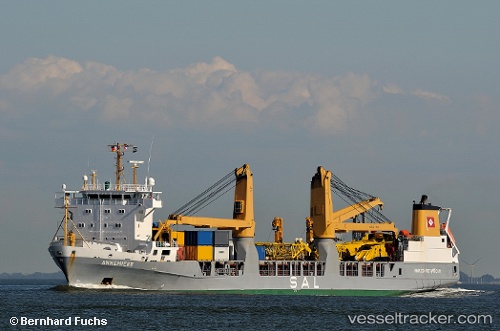
 ANNEMIEKE
Current Status
Where is the vessel?
ANNEMIEKE is currently in 49 nm W of Torsminde, based on AIS data received less than 1h ago.
Latest AIS update:
Current position: 56.46526° N, 6.66554° E (49 nm W of Torsminde)
Average speed (last 7 days): Loading…
Average speed (last 30 days): Loading…
Vessel profile: ANNEMIEKE is a General Cargo with dimensions m x m.
This page combines live AIS, route history, probable destination signals, nearby traffic, and port activity for practical vessel monitoring.
The current position of vessel ANNEMIEKE is 56.46526 lat / 6.66554 lng. Updated: 2026-04-09 06:08:45 UTCNearest reference points:
- 36 nm W of HVIDE SANDE
- Near Thyborøn
- Near Blavand
Currently sailing under the flag of Netherlands ![]()
Details:
Live Vessel ANNEMIEKE Analytics (details, animations, etc.)
Recent AIS points (UTC):
2026-04-08 23:40:21 UTC · 58.05347, 5.41691 · SOG 15.2 kn · COG 156°2026-04-09 01:32:51 UTC · 57.58695, 5.77761 · SOG 16 kn · COG 157°
2026-04-09 04:03:47 UTC · 56.97325, 6.28684 · SOG 16 kn · COG 155°
2026-04-09 06:08:45 UTC · 56.46526, 6.66554 · SOG 15.7 kn · COG 155°