 vesseltracker.com
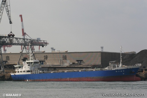
 HARIMA 21
Current Status
Where is the vessel?
HARIMA 21 is currently in Near Kuala Enok, based on AIS data received about 9d ago.
Latest AIS update:
Current position: 0.50693° S, 103.38693° E (Near Kuala Enok)
Average speed (last 7 days): Loading…
Average speed (last 30 days): Loading…
Vessel profile: HARIMA 21 is a General Cargo Ship with dimensions 76m x 12m.
This page combines live AIS, route history, probable destination signals, nearby traffic, and port activity for practical vessel monitoring.
The current position of vessel HARIMA 21 is -0.50693 lat / 103.38693 lng. Updated: 2026-03-22 18:33:31 UTCNearest reference points:
- 16 nm E of Kualamandah
- Near Jabung Terminal
- Near JAMBI
Currently sailing under the flag of Indonesia ![]()
HARIMA 21 built in 1996 year
Deadweight:
1566 tDetails:
Live Vessel HARIMA 21 Analytics (details, animations, etc.)
Recent AIS points (UTC):
2026-03-18 14:12:02 UTC · 0.25414, 103.83756 · SOG 7.9 kn · COG -1°2026-03-18 14:12:02 UTC · 0.25414, 103.83756 · SOG 7.9 kn · COG -1°
2026-03-18 14:12:02 UTC · 0.25414, 103.83756 · SOG 7.9 kn · COG -1°
2026-03-22 18:33:31 UTC · -0.50693, 103.38693 · SOG 0 kn · COG -1°
2026-03-22 18:33:31 UTC · -0.50693, 103.38693 · SOG 0 kn · COG -1°
2026-03-22 18:33:31 UTC · -0.50693, 103.38693 · SOG 0 kn · COG -1°