 vesseltracker.com
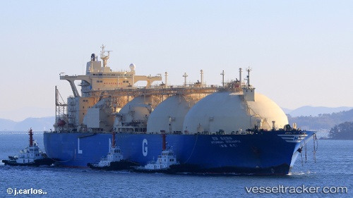
 HYUNDAI OCEANPIA
Current Status
Where is the vessel?
HYUNDAI OCEANPIA is currently in 53 nm N of Bundaberg, based on AIS data received about 1h ago.
Latest AIS update:
Current position: 23.87798° S, 152.51553° E (53 nm N of Bundaberg)
Average speed (last 7 days): Loading…
Average speed (last 30 days): Loading…
Vessel profile: HYUNDAI OCEANPIA is a LNG Tanker with dimensions 288m x 48m.
This page combines live AIS, route history, probable destination signals, nearby traffic, and port activity for practical vessel monitoring.
The current position of vessel HYUNDAI OCEANPIA is -23.87798 lat / 152.51553 lng. Updated: 2026-03-29 19:34:58 UTCNearest reference points:
- Near Bundaberg
- Near Boyne Island
- Near Gladstone Harbor
Currently sailing under the flag of Marshall Islands ![]()
HYUNDAI OCEANPIA built in 2000 year
Deadweight:
77512 tDetails:
Live Vessel HYUNDAI OCEANPIA Analytics (details, animations, etc.)
Recent AIS points (UTC):
2026-03-29 14:12:02 UTC · -23.85091, 151.32449 · SOG 11.4 kn · COG 121°2026-03-29 15:54:13 UTC · -23.81091, 151.61455 · SOG 14.3 kn · COG 91°
2026-03-29 18:18:56 UTC · -23.96066, 152.22540 · SOG 14.5 kn · COG 99°
2026-03-29 19:34:58 UTC · -23.87798, 152.51553 · SOG 15.5 kn · COG 19°