 vesseltracker.com
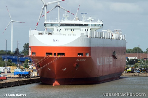
 Tamesis
Current Status
Where is the vessel?
Tamesis is currently in 83 nm W of Lince, based on AIS data received about 3h ago.
Latest AIS update:
Current position: 12.16500° N, 78.46333° W (83 nm W of Lince)
Average speed (last 7 days): Loading…
Average speed (last 30 days): Loading…
Vessel profile: Tamesis is a Vehicles Carrier with dimensions 244m x 32m.
This page combines live AIS, route history, probable destination signals, nearby traffic, and port activity for practical vessel monitoring.
The current position of vessel Tamesis is 12.16500 lat / -78.46333 lng. Updated: 2026-03-26 13:22:14 UTCNearest reference points:
- 62 nm NE of Playón Chico
Currently sailing under the flag of Norway ![]()
Tamesis built in 2000 year
Deadweight:
39516 tDetails:
Live Vessel Tamesis Analytics (details, animations, etc.)
Recent AIS points (UTC):
2026-03-26 08:16:11 UTC · 13.15333, -77.91167 · SOG 13 kn · COG -1°2026-03-26 09:55:11 UTC · 12.83833, -78.08667 · SOG 13 kn · COG -1°
2026-03-26 12:22:11 UTC · 12.36333, -78.35333 · SOG 13 kn · COG -1°
2026-03-26 13:22:14 UTC · 12.16500, -78.46333 · SOG 13 kn · COG -1°