 vesseltracker.com
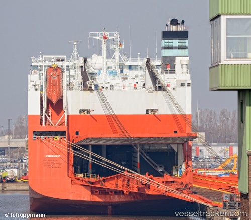
 Tamerlane
Current Status
Where is the vessel?
Tamerlane is currently in 120 nm NE of Nags Head, based on AIS data received about 1d ago.
Latest AIS update:
Current position: 36.75101° N, 73.33585° W (120 nm NE of Nags Head)
Average speed (last 7 days): Loading…
Average speed (last 30 days): Loading…
Vessel profile: Tamerlane is a Vehicles Carrier with dimensions 245m x 32m.
This page combines live AIS, route history, probable destination signals, nearby traffic, and port activity for practical vessel monitoring.
The current position of vessel Tamerlane is 36.75101 lat / -73.33585 lng. Updated: 2026-04-10 07:45:21 UTCNearest reference points:
- 48 nm E of Nags Head
- 45 nm NE of Nags Head
- 91 nm E of Rodanthe
Currently sailing under the flag of Norway ![]()
Tamerlane built in 2001 year
Deadweight:
38500 tDetails:
Live Vessel Tamerlane Analytics (details, animations, etc.)
Recent AIS points (UTC):
2026-04-10 02:19:30 UTC · 36.75021, -74.66367 · SOG 11.3 kn · COG 86°2026-04-10 04:16:41 UTC · 36.74793, -74.19047 · SOG 11.9 kn · COG 84°
2026-04-10 06:28:51 UTC · 36.75070, -73.64696 · SOG 12.1 kn · COG 91°
2026-04-10 07:45:21 UTC · 36.75101, -73.33585 · SOG 12 kn · COG 92°