 vesseltracker.com
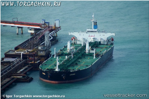
 ACHERON
Current Status
Where is the vessel?
ACHERON is currently in 52 nm NE of PENGERANG, based on AIS data received about 1d ago.
Latest AIS update:
Current position: 1.93527° N, 104.79175° E (52 nm NE of PENGERANG)
Average speed (last 7 days): Loading…
Average speed (last 30 days): Loading…
Vessel profile: ACHERON is a Crude Oil Tanker with dimensions m x m.
This page combines live AIS, route history, probable destination signals, nearby traffic, and port activity for practical vessel monitoring.
The current position of vessel ACHERON is 1.93527 lat / 104.79175 lng. Updated: 2026-04-10 08:06:10 UTCNearest reference points:
- 51 nm NE of PENGERANG
- 53 nm NE of PENGERANG
- 55 nm NE of PENGERANG
Currently sailing under the flag of Barbados ![]()
Details:
Live Vessel ACHERON Analytics (details, animations, etc.)
Recent AIS points (UTC):
2026-04-10 01:35:34 UTC · 1.93717, 104.79340 · SOG 0.5 kn · COG -1°2026-04-10 04:12:14 UTC · 1.93943, 104.79105 · SOG 0.1 kn · COG 171°
2026-04-10 05:57:10 UTC · 1.93952, 104.79090 · SOG 0.1 kn · COG 162°
2026-04-10 08:06:10 UTC · 1.93527, 104.79175 · SOG 0 kn · COG 350°