 vesseltracker.com
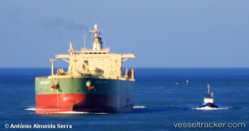
 Santa Cruz I
Current Status
Where is the vessel?
Santa Cruz I is currently in Near Map Ta Phut, based on AIS data received about 1h ago.
Latest AIS update:
Current position: 12.56597° N, 101.21935° E (Near Map Ta Phut)
Average speed (last 7 days): Loading…
Average speed (last 30 days): Loading…
Vessel profile: Santa Cruz I is a Crude Oil Tanker with dimensions 239m x 38m.
This page combines live AIS, route history, probable destination signals, nearby traffic, and port activity for practical vessel monitoring.
The current position of vessel Santa Cruz I is 12.56597 lat / 101.21935 lng. Updated: 2026-04-09 19:53:00 UTCNearest reference points:
- 11 nm S of Map Ta Phut
- Near SATTAHIP
- 33 nm S of SATTAHIP
Currently sailing under the flag of Liberia ![]()
Santa Cruz I built in 2002 year
Deadweight:
84999 tDetails:
Live Vessel Santa Cruz I Analytics (details, animations, etc.)
Recent AIS points (UTC):
2026-04-09 14:20:00 UTC · 12.56573, 101.21815 · SOG 0 kn · COG 159°2026-04-09 16:13:59 UTC · 12.56597, 101.21872 · SOG 0 kn · COG 175°
2026-04-09 17:47:00 UTC · 12.56595, 101.21923 · SOG 0 kn · COG 187°
2026-04-09 19:53:00 UTC · 12.56597, 101.21935 · SOG 0 kn · COG 189°