 vesseltracker.com
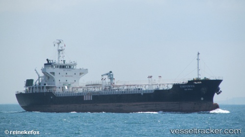
 EMPOWER
Current Status
Where is the vessel?
EMPOWER is currently in Near JURONG ISLAND, based on AIS data received about 1h ago.
Latest AIS update:
Current position: 1.22638° N, 103.67385° E (Near JURONG ISLAND)
Average speed (last 7 days): Loading…
Average speed (last 30 days): Loading…
Vessel profile: EMPOWER is a Oil Products Tanker with dimensions 109m x 18m.
This page combines live AIS, route history, probable destination signals, nearby traffic, and port activity for practical vessel monitoring.
The current position of vessel EMPOWER is 1.22638 lat / 103.67385 lng. Updated: 2026-04-02 09:36:22 UTCNearest reference points:
- Near Pulau Ayer Chawan
- Near JURONG ISLAND
- Near Tuas
Currently sailing under the flag of Malaysia ![]()
EMPOWER built in 2003 year
Deadweight:
7820 tDetails:
Live Vessel EMPOWER Analytics (details, animations, etc.)
Recent AIS points (UTC):
2026-04-02 03:32:09 UTC · 1.22633, 103.67385 · SOG 0 kn · COG 336°2026-04-02 05:59:35 UTC · 1.22639, 103.67386 · SOG 0 kn · COG 337°
2026-04-02 07:41:34 UTC · 1.22637, 103.67383 · SOG 0.1 kn · COG 336°
2026-04-02 09:36:22 UTC · 1.22638, 103.67385 · SOG 0 kn · COG 336°