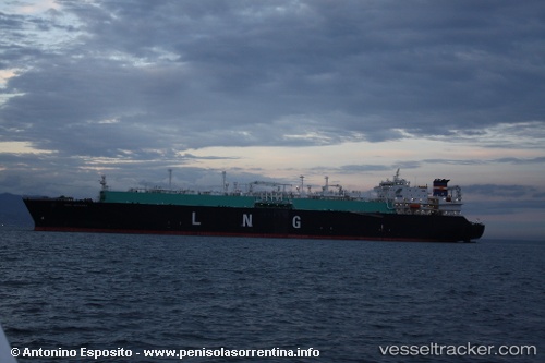
.
Vessel photo of Seri Angkasa (IMO 9321665) vesseltracker.com

MY flag Seri Angkasa

Vessel type: Lng Tanker | IMO: 9321665 | MMSI: MMSI: 533957000
Call sign: 9MGW4 | Dimensions: 282 m x 284 m
Current Status

Where is the vessel?

Seri Angkasa is currently in 117 nm N of PANGKAL BALAM, based on AIS data received about 2h ago.

Latest AIS update:

Current position: 0.25782° S, 106.75637° E (117 nm N of PANGKAL BALAM)

Average speed (last 7 days): Loading…

Average speed (last 30 days): Loading…

Vessel profile: Seri Angkasa is a Lng Tanker with dimensions 282m x 284m.

This page combines live AIS, route history, probable destination signals, nearby traffic, and port activity for practical vessel monitoring.

The current position of vessel Seri Angkasa is -0.25782 lat / 106.75637 lng. Updated: 2026-03-30 13:15:31 UTC
Nearest reference points:
  • 69 nm NE of Exspan
  • Near PANGKAL BALAM
  • 46 nm NW of Tanjung Pandan

Currently sailing under the flag of Malaysia MY flag

Seri Angkasa built in 2006 year

Deadweight:
83407 t

Details:

Live Vessel Seri Angkasa Analytics (details, animations, etc.)


Recent AIS points (UTC):
2026-03-29 23:13:41 UTC · -1.72711, 108.15392 · SOG 15 kn · COG -1°
2026-03-30 09:07:58 UTC · 0.10490, 106.41258 · SOG 15.6 kn · COG 322°
2026-03-30 13:15:31 UTC · -0.25782, 106.75637 · SOG 16.3 kn · COG -1°

Track of the vessel in the last 28 days


UTC: --
Start: -- Track timeline (UTC) End: --
Encountered: --


Link to the map:


Find another ship

Seri_Angkasa (533957000) last ports (portcalls and passsages)

Ulsan | 2025-09-14 11:54:14
BINTULU | 2025-08-23 23:03:19
BUSAN NEW PORT | 2025-08-11 02:17:52
BUSAN NEW PORT | 2025-07-21 06:58:39
ANJEONG | 2025-07-20 03:58:03
GOHYEON | 2025-07-20 03:24:12
BINTULU | 2025-06-24 03:02:42
PENGERANG | 2025-06-14 02:20:43
GLADSTONE | 2025-05-28 15:43:48
SUNGAI UDANG | 2025-05-13 03:21:13
BATU AMPAR | 2025-05-12 17:35:07
PENGERANG | 2025-05-12 16:25:55
GLADSTONE | 2025-04-30 04:40:47
DAESAN | 2025-04-15 09:43:50
PYEONGTAEK | 2025-04-14 07:29:06
GLADSTONE | 2025-03-31 17:16:42
PENGERANG | 2025-03-16 23:08:30
GLADSTONE | 2025-03-03 04:50:09
PENGERANG | 2025-02-11 00:08:14
GLADSTONE | 2025-01-28 15:05:15
PENGERANG | 2025-01-08 23:13:54
GLADSTONE | 2024-12-24 22:44:29
PENGERANG | 2024-12-11 00:39:26
GLADSTONE | 2024-11-26 11:37:53
Yokohama | 2024-11-09 01:58:37
KIMITSU | 2024-11-08 01:58:04
Yokosuka | 2024-11-08 01:22:46
Gladstone Harbor | 2024-10-09 09:17:26
Yosu | 2024-09-19 23:40:12
Map Ta Phut | 2024-09-04 00:17:31
Singapore | 2024-08-23 08:34:35
Gladstone Harbor | 2024-08-07 16:21:26
Da Chan Bay | 2024-07-12 00:55:20
Da Chan Bay | 2024-07-06 02:50:08
Da Chan Bay | 2024-07-02 02:25:22
Da Chan Bay | 2024-06-28 02:14:37
Da Chan Bay | 2024-06-23 07:08:01
Da Chan Bay | 2024-06-15 04:00:24
Shekou | 2024-06-15 02:15:50
Singapore | 2024-06-04 11:32:01
Gladstone Harbor | 2024-05-23 14:59:23
Gladstone Harbor | 2024-04-10 03:14:46
Yokosuka | 2024-03-31 01:00:42
Yokohama | 2024-03-30 00:59:03
Kawasaki | 2024-03-30 00:02:06
Gladstone Harbor | 2024-02-08 02:13:44
Gladstone Harbor | 2024-01-11 15:20:40
Gladstone Harbor | 2023-11-18 06:42:50
Batangas | 2023-10-28 03:28:59
HITACHINAKA | 2023-09-15 00:07:47
Yokkaichi | 2023-06-22 02:31:55
Yosu | 2023-06-08 02:52:00
Shimotsui | 2023-05-11 23:53:45
Matsuga-hana | 2023-05-11 22:18:48
Yokosuka | 2023-04-14 03:43:21
Chibai | 2023-01-20 02:51:43
Higashi-Iwase | 2022-11-29 05:55:27
Sambu | 2022-10-07 07:31:48
Shimizu | 2022-08-30 01:30:32
Gladstone Harbor | 2022-05-06 19:10:21