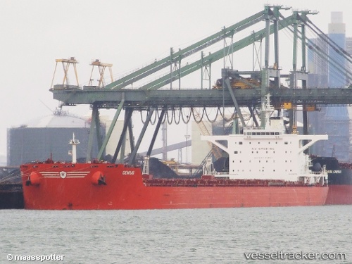
.
Vessel photo of Geniuship (IMO 9398759) vesseltracker.com

Geniuship

Vessel type: Bulk Carrier | IMO: 9398759 | MMSI: MMSI: 538006628
Call sign: V7PG8 | Dimensions: 45 m x 288 m
Current Status

Where is the vessel?

Geniuship is currently in Near TANAH MERAH, based on AIS data received about 1h ago.

Latest AIS update:

Current position: 1.28999° N, 104.04513° E (Near TANAH MERAH)

Average speed (last 7 days): Loading…

Average speed (last 30 days): Loading…

Vessel profile: Geniuship is a Bulk Carrier with dimensions 45m x 288m.

This page combines live AIS, route history, probable destination signals, nearby traffic, and port activity for practical vessel monitoring.

The current position of vessel Geniuship is 1.28999 lat / 104.04513 lng. Updated: 2026-03-26 15:37:42 UTC
Nearest reference points:
  • Near TANAH MERAH
  • Near Changi
  • Near Tanjung Setapa
Details:

Live Vessel Geniuship Analytics (details, animations, etc.)


Recent AIS points (UTC):
2026-03-26 10:04:42 UTC · 1.28945, 104.04511 · SOG 0 kn · COG 65°
2026-03-26 11:52:42 UTC · 1.28947, 104.04509 · SOG 0 kn · COG 66°
2026-03-26 14:04:46 UTC · 1.28968, 104.04522 · SOG 0 kn · COG 66°
2026-03-26 15:37:42 UTC · 1.28999, 104.04513 · SOG 0 kn · COG 69°

Track of the vessel in the last 28 days


UTC: --
Start: -- Track timeline (UTC) End: --
Encountered: --


Link to the map:


Find another ship

Geniuship (538006628) last ports (portcalls and passsages)

Jingjiang | 2025-09-05 19:42:54
Chongming | 2025-09-05 07:23:53
Taicang | 2025-09-03 17:32:26
ZHOUSHAN | 2025-08-31 07:16:50
Selat Lombok | 2025-08-21 06:13:35
PORT WALCOTT | 2025-08-16 07:18:39
Samson Point | 2025-08-16 06:05:40
Selat Lombok | 2025-08-06 10:28:41
TANAH MERAH | 2025-07-30 20:56:37
PENGERANG | 2025-07-30 20:04:40
Honshu | 2025-07-17 22:58:25
KASHIMA | 2025-07-16 06:59:37
KASHIMA | 2025-07-12 06:58:13
Kashima Ko | 2025-07-12 06:34:19
Muroran | 2025-07-06 20:59:23
Newcastle | 2025-06-15 14:21:21
JINGTANG | 2025-04-29 07:18:01
Selat Lombok | 2025-04-11 09:46:50
Dampier | 2025-04-06 07:10:22
Selat Lombok | 2025-03-31 15:11:18
JINGTANG | 2025-03-16 06:22:19
PENGERANG | 2025-03-02 04:09:25
TANAH MERAH | 2025-03-01 10:23:13
PULAU SAMBU | 2025-03-01 08:32:28
Saldanha Bay | 2025-02-01 09:56:34
SALDANHA | 2025-01-31 13:00:29
SALDANHA | 2025-01-27 11:56:34
SALDANHA | 2025-01-23 11:01:12
Saldanha Bay | 2025-01-23 10:20:47
PULAU SAMBU | 2024-12-29 16:10:52
PENGERANG | 2024-12-10 17:24:11
Singapore | 2024-12-10 07:44:47
TANAH MERAH | 2024-12-10 00:21:32
BATU AMPAR | 2024-12-09 23:07:14
BUKOM ISLAND | 2024-12-09 21:28:37
Paradip | 2024-09-19 22:29:25
Paradip | 2024-09-15 22:10:57
Paradip | 2024-09-11 20:55:23
Gladstone Harbor | 2024-08-16 20:06:52
Taicang | 2024-07-17 03:17:47
Wusong | 2024-07-17 00:57:32
Jingjiang | 2024-07-16 20:21:16
Dampier | 2024-06-23 17:17:22
Jingjiang | 2024-06-10 12:08:23
Taicang | 2024-06-07 07:23:58
Wusong | 2024-06-07 04:58:51
Singapore | 2024-05-24 09:08:40
Saldanha Bay | 2024-04-25 15:24:02
Saldanha Bay | 2024-04-19 04:31:41
Singapore | 2024-03-09 02:50:18
Gladstone Harbor | 2024-02-19 16:11:40
Singapore | 2023-12-21 18:42:15
Strait Of Gibraltar | 2023-09-16 21:50:18
Algeciras | 2023-09-14 17:08:03
Alexandria | 2023-09-03 10:42:56
Strait Of Gibraltar | 2023-08-26 19:51:10
Tubarao | 2023-08-08 08:24:20
Sambu | 2023-06-28 17:54:17
Gladstone Harbor | 2023-06-10 14:31:53
Gladstone Harbor | 2023-01-10 20:55:24
Selat Lombok | 2022-11-04 11:56:51
Port Headland | 2022-10-31 09:03:08
Taku Bar | 2022-10-05 16:52:01
Dagu Bar | 2022-10-04 04:38:45
Port Headland | 2022-09-13 02:02:38
Samson Point | 2022-08-09 01:06:19
Newcastle | 2022-07-01 04:34:07
Newcastle | 2022-06-26 19:40:47
Yokosuka | 2022-06-05 01:53:10
Yokohama | 2022-06-05 01:21:06
Singapore | 2022-05-08 16:49:38
Selat Lombok | 2022-01-08 10:06:41
Port Headland | 2022-01-04 05:47:51
Selat Lombok | 2021-12-28 04:46:47
Wusong | 2021-12-18 11:38:18