 vesseltracker.com
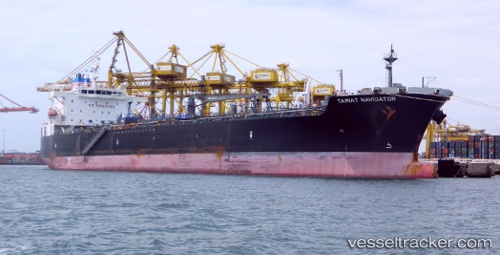
 Tamiat Navigator
Current Status
Where is the vessel?
Tamiat Navigator is currently in 81 nm SW of Lajes das Flores, based on AIS data received about 15h ago.
Latest AIS update:
Current position: 38.16167° N, 31.90667° W (81 nm SW of Lajes das Flores)
Average speed (last 7 days): Loading…
Average speed (last 30 days): Loading…
Vessel profile: Tamiat Navigator is a Chemical Oil Products Tanker with dimensions 183m x 32m.
This page combines live AIS, route history, probable destination signals, nearby traffic, and port activity for practical vessel monitoring.
The current position of vessel Tamiat Navigator is 38.16167 lat / -31.90667 lng. Updated: 2026-04-10 07:17:43 UTCCurrently sailing under the flag of Panama ![]()
Tamiat Navigator built in 2010 year
Deadweight:
46625 tDetails:
Live Vessel Tamiat Navigator Analytics (details, animations, etc.)
Recent AIS points (UTC):
2026-04-10 02:04:37 UTC · 37.94926, -32.96123 · SOG 9.6 kn · COG 69°2026-04-10 03:20:42 UTC · 38.01667, -32.71833 · SOG 9 kn · COG -1°
2026-04-10 05:27:37 UTC · 38.10070, -32.29695 · SOG 9.5 kn · COG 85°
2026-04-10 07:17:43 UTC · 38.16167, -31.90667 · SOG 12 kn · COG -1°