 vesseltracker.com
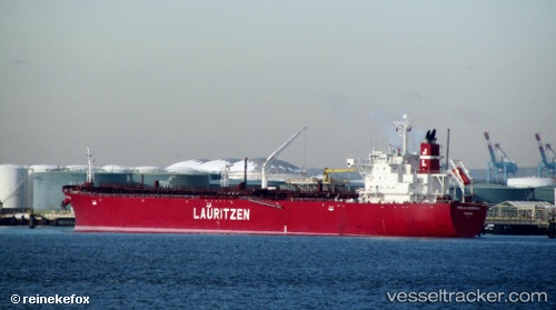
 ULYSSES I
Current Status
Where is the vessel?
ULYSSES I is currently in Near Chrome, based on AIS data received about 1h ago.
Latest AIS update:
Current position: 40.55738° N, 74.23968° W (Near Chrome)
Average speed (last 7 days): Loading…
Average speed (last 30 days): Loading…
Vessel profile: ULYSSES I is a Oil Products Tanker with dimensions m x m.
This page combines live AIS, route history, probable destination signals, nearby traffic, and port activity for practical vessel monitoring.
The current position of vessel ULYSSES I is 40.55738 lat / -74.23968 lng. Updated: 2026-04-08 23:45:58 UTCNearest reference points:
- Near Bayway
- Near Elizabethport
- Near South Amboy
Currently sailing under the flag of Liberia ![]()
Details:
Live Vessel ULYSSES I Analytics (details, animations, etc.)
Recent AIS points (UTC):
2026-04-08 18:10:00 UTC · 40.55738, -74.23969 · SOG 0 kn · COG 246°2026-04-08 19:31:01 UTC · 40.55737, -74.23969 · SOG 0 kn · COG 246°
2026-04-08 21:21:58 UTC · 40.55736, -74.23968 · SOG 0 kn · COG 247°
2026-04-08 23:45:58 UTC · 40.55738, -74.23968 · SOG 0 kn · COG 247°