 vesseltracker.com
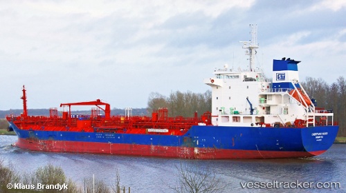
 PANCARANKHATULISTIWA
Current Status
Where is the vessel?
PANCARANKHATULISTIWA is currently in 16 nm NE of Mauk, based on AIS data received about 1h ago.
Latest AIS update:
Current position: 5.82595° S, 106.64597° E (16 nm NE of Mauk)
Average speed (last 7 days): Loading…
Average speed (last 30 days): Loading…
Vessel profile: PANCARANKHATULISTIWA is a Oil/Chemical Tanker with dimensions m x m.
This page combines live AIS, route history, probable destination signals, nearby traffic, and port activity for practical vessel monitoring.
The current position of vessel PANCARANKHATULISTIWA is -5.82595 lat / 106.64597 lng. Updated: 2026-03-30 13:25:12 UTCNearest reference points:
- 19 nm N of Cilincing
- Near New Priok Port
- Near Manggadua
Currently sailing under the flag of Indonesia ![]()
Details:
Live Vessel PANCARANKHATULISTIWA Analytics (details, animations, etc.)
Recent AIS points (UTC):
2026-03-30 08:21:00 UTC · -5.85455, 106.01072 · SOG 6.9 kn · COG 49°2026-03-30 09:30:51 UTC · -5.82797, 106.14245 · SOG 7.7 kn · COG 93°
2026-03-30 12:22:01 UTC · -5.83425, 106.50945 · SOG 7.5 kn · COG 90°
2026-03-30 13:25:12 UTC · -5.82595, 106.64597 · SOG 8 kn · COG 84°