 vesseltracker.com
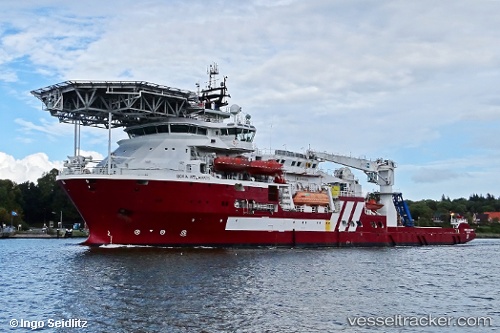
 Boka Atlantis
Current Status
Where is the vessel?
Boka Atlantis is currently in Near Montrose, based on AIS data received less than 1h ago.
Latest AIS update:
Current position: 56.70242° N, 2.46818° W (Near Montrose)
Average speed (last 7 days): Loading…
Average speed (last 30 days): Loading…
Vessel profile: Boka Atlantis is a Offshore Support Vessel with dimensions 116m x 22m.
This page combines live AIS, route history, probable destination signals, nearby traffic, and port activity for practical vessel monitoring.
The current position of vessel Boka Atlantis is 56.70242 lat / -2.46818 lng. Updated: 2026-03-31 18:09:23 UTCNearest reference points:
- Near BROUGHTY FERRY
- Near Aberdeen
- Near North Berwick
Currently sailing under the flag of Marshall Is ![]()
Boka Atlantis built in 2011 year
Deadweight:
5662 tDetails:
Live Vessel Boka Atlantis Analytics (details, animations, etc.)
Recent AIS points (UTC):
2026-03-31 11:25:10 UTC · 56.70240, -2.46817 · SOG 0 kn · COG 286°2026-03-31 14:15:23 UTC · 56.70243, -2.46816 · SOG 0 kn · COG 286°
2026-03-31 15:21:18 UTC · 56.70240, -2.46817 · SOG 0 kn · COG 287°
2026-03-31 18:09:23 UTC · 56.70242, -2.46818 · SOG 0 kn · COG 287°