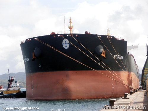
.
Vessel photo of Boston (IMO 9445966) vesseltracker.com

MH flag Boston

Vessel type: Bulk Carrier | IMO: 9445966 | MMSI: MMSI: 538002934
Call sign: V7NA5 | Dimensions: 292 m x 45 m
Current Status

Where is the vessel?

Boston is currently in Near ILHA GUAIBA, based on AIS data received about 1h ago.

Latest AIS update:

Current position: 23.01252° S, 44.03285° W (Near ILHA GUAIBA)

Average speed (last 7 days): Loading…

Average speed (last 30 days): Loading…

Vessel profile: Boston is a Bulk Carrier with dimensions 292m x 45m.

This page combines live AIS, route history, probable destination signals, nearby traffic, and port activity for practical vessel monitoring.

The current position of vessel Boston is -23.01252 lat / -44.03285 lng. Updated: 2026-03-29 01:22:45 UTC
Nearest reference points:
  • Near ILHA GUAIBA
  • Near SANTA RITA
  • Near CUNHAMBEBE

Currently sailing under the flag of Marshall Is MH flag

Boston built in 2007 year

Deadweight:
177827 t

Details:

Live Vessel Boston Analytics (details, animations, etc.)


Recent AIS points (UTC):
2026-03-28 19:56:14 UTC · -23.01253, -44.03282 · SOG 0 kn · COG -1°
2026-03-28 21:21:39 UTC · -23.01247, -44.03285 · SOG 0 kn · COG -1°
2026-03-28 23:47:15 UTC · -23.01257, -44.03281 · SOG 0 kn · COG -1°
2026-03-29 01:22:45 UTC · -23.01252, -44.03285 · SOG 0 kn · COG -1°

Track of the vessel in the last 28 days


UTC: --
Start: -- Track timeline (UTC) End: --
Encountered: --


Link to the map:


Find another ship

Boston (538002934) last ports (portcalls and passsages)

GLADSTONE | 2025-08-27 07:44:25
LUOYUAN | 2025-08-06 09:46:41
LUOYUAN | 2025-08-02 08:30:23
LUOYUAN | 2025-07-10 07:28:52
LUOYUAN | 2025-07-06 06:38:32
LUOYUAN | 2025-07-02 05:48:04
LUOYUAN | 2025-06-26 06:16:10
LUOYUAN | 2025-06-20 19:45:17
Nantong | 2025-06-17 10:14:58
Zhangjiagang | 2025-06-15 02:22:31
Taicang | 2025-06-14 20:51:15
Wusong | 2025-06-14 18:47:23
Jingjiang | 2025-06-14 13:36:07
PENGERANG | 2025-06-01 08:48:50
TANAH MERAH | 2025-05-31 15:16:23
PULAU SAMBU | 2025-05-31 13:59:04
Port Elizabeth | 2025-03-25 07:11:25
JURONG ISLAND | 2025-03-02 18:16:55
BUKOM ISLAND | 2025-03-02 17:20:17
TEKONG ISLAND | 2025-03-02 01:42:30
TANAH MERAH | 2025-03-01 22:32:30
PENGERANG | 2025-03-01 21:24:46
Bayuquan | 2025-02-16 21:57:43
HUANGHUA | 2025-02-14 09:25:41
PENGERANG | 2025-01-30 13:24:14
TANAH MERAH | 2025-01-29 05:20:04
BATU AMPAR | 2025-01-28 23:14:15
PULAU SAMBU | 2025-01-28 22:04:46
BUKOM ISLAND | 2025-01-28 21:09:09
Port Louis | 2025-01-14 13:32:51
Port Elizabeth | 2024-11-15 13:54:32
Port Louis | 2024-11-06 20:19:41
Singapore | 2024-10-25 10:27:14
Rizhao | 2024-10-11 03:50:09
Selat Lombok | 2024-08-06 01:44:14
Whyalla | 2024-07-18 00:15:27
Whyalla | 2024-07-13 22:59:35
Panjang | 2024-07-02 11:43:16
Fangcheng | 2024-06-25 09:13:33
Fangcheng | 2024-06-21 08:55:46
Selat Lombok | 2024-04-19 05:22:13
Whyalla | 2024-03-30 01:21:58
Whyalla | 2024-03-26 00:04:19
Fangcheng | 2024-02-03 18:39:35
Singapore | 2024-01-25 17:47:08
Saldanha Bay | 2024-01-05 00:38:13
Saldanha Bay | 2023-12-29 05:09:08
Cape Town | 2023-12-28 03:34:46
Cape Town | 2023-12-24 03:12:18
Cape Of Good Hope | 2023-12-24 00:07:22
Sitrah Anchorage | 2023-11-30 15:56:02
Sitrah Anchorage | 2023-09-17 01:22:25
Singapore | 2023-07-07 22:21:50
Cai Mep | 2023-06-17 06:15:15
Vung Tau | 2023-06-17 04:05:47
Taicang | 2023-05-03 04:09:46
Wusong | 2023-05-03 02:21:34
Singapore | 2023-04-21 20:44:24
Sebang | 2023-04-19 14:35:37
Sao Luiz | 2022-12-01 11:07:33
Ijmuiden | 2022-11-04 23:06:54
Richards Bay | 2022-09-13 13:52:03
Sambu | 2022-07-26 07:26:24
Port Headland | 2022-05-05 19:04:08
Port Louis | 2022-03-12 12:49:47
Saldanha Bay | 2022-02-27 06:30:35
Mormugao | 2022-02-04 02:55:56
Singapore | 2022-01-21 00:05:43