 vesseltracker.com
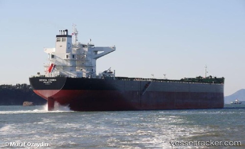
 MINH PROVIDENCE
Current Status
Where is the vessel?
MINH PROVIDENCE is currently in Near Mangaratiba, based on AIS data received about 2h ago.
Latest AIS update:
Current position: 22.97739° S, 43.96516° W (Near Mangaratiba)
Average speed (last 7 days): Loading…
Average speed (last 30 days): Loading…
Vessel profile: MINH PROVIDENCE is a Bulk Carrier with dimensions m x m.
This page combines live AIS, route history, probable destination signals, nearby traffic, and port activity for practical vessel monitoring.
The current position of vessel MINH PROVIDENCE is -22.97739 lat / -43.96516 lng. Updated: 2026-03-28 15:32:20 UTCNearest reference points:
- Near ILHA GUAIBA
- Near SANTA RITA
- Near CUNHAMBEBE
Currently sailing under the flag of Marshall Islands ![]()
Details:
Live Vessel MINH PROVIDENCE Analytics (details, animations, etc.)
Recent AIS points (UTC):
2026-03-28 09:53:18 UTC · -22.97882, -43.96285 · SOG 0.1 kn · COG 0°2026-03-28 11:32:18 UTC · -22.97676, -43.96060 · SOG 0 kn · COG 277°
2026-03-28 14:05:17 UTC · -22.97781, -43.96113 · SOG 0.1 kn · COG 307°
2026-03-28 15:32:20 UTC · -22.97739, -43.96516 · SOG 0 kn · COG 65°