 vesseltracker.com
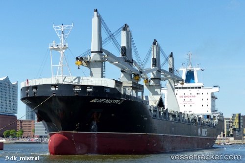
 Blue Master Ii
Current Status
Where is the vessel?
Blue Master Ii is currently in Near Helgoland, based on AIS data received about 2h ago.
Latest AIS update:
Current position: 54.02814° N, 7.78495° E (Near Helgoland)
Average speed (last 7 days): Loading…
Average speed (last 30 days): Loading…
Vessel profile: Blue Master Ii is a Multi Purpose Carrier with dimensions 200m x 30m.
This page combines live AIS, route history, probable destination signals, nearby traffic, and port activity for practical vessel monitoring.
The current position of vessel Blue Master Ii is 54.02814 lat / 7.78495 lng. Updated: 2026-03-27 17:53:08 UTCNearest reference points:
- Near Helgoland
- Near Wangerooge
- Near Horumersiel
Currently sailing under the flag of Marshall Is ![]()
Blue Master Ii built in 2013 year
Deadweight:
37444 tDetails:
Live Vessel Blue Master Ii Analytics (details, animations, etc.)
Recent AIS points (UTC):
2026-03-27 12:03:38 UTC · 53.67834, 9.50633 · SOG 13.5 kn · COG 346°2026-03-27 14:16:02 UTC · 53.84276, 8.87888 · SOG 8.8 kn · COG 260°
2026-03-27 15:37:43 UTC · 53.95848, 8.61509 · SOG 10.6 kn · COG 295°
2026-03-27 17:53:08 UTC · 54.02814, 7.78495 · SOG 15.6 kn · COG 274°