 vesseltracker.com
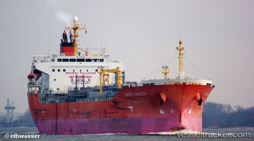
 Chem Ranger
Current Status
Where is the vessel?
Chem Ranger is currently in 210 nm E of Tamatave, based on AIS data received less than 1h ago.
Latest AIS update:
Current position: 17.03075° S, 52.90255° E (210 nm E of Tamatave)
Average speed (last 7 days): Loading…
Average speed (last 30 days): Loading…
Vessel profile: Chem Ranger is a Chemical Oil Products Tanker with dimensions 159m x 27m.
This page combines live AIS, route history, probable destination signals, nearby traffic, and port activity for practical vessel monitoring.
The current position of vessel Chem Ranger is -17.03075 lat / 52.90255 lng. Updated: 2026-04-01 00:10:59 UTCNearest reference points:
- 183 nm E of Tamatave
- 210 nm NE of Tamatave
- 243 nm E of Nosy-Be
Currently sailing under the flag of Marshall Is ![]()
Chem Ranger built in 2010 year
Deadweight:
26198 tDetails:
Live Vessel Chem Ranger Analytics (details, animations, etc.)
Recent AIS points (UTC):
2026-03-31 18:21:59 UTC · -15.79570, 53.64938 · SOG 14.8 kn · COG 208°2026-03-31 19:38:04 UTC · -16.06672, 53.48963 · SOG 14.8 kn · COG 208°
2026-03-31 21:58:40 UTC · -16.56197, 53.19382 · SOG 14.7 kn · COG 210°
2026-04-01 00:10:59 UTC · -17.03075, 52.90255 · SOG 14.5 kn · COG 208°