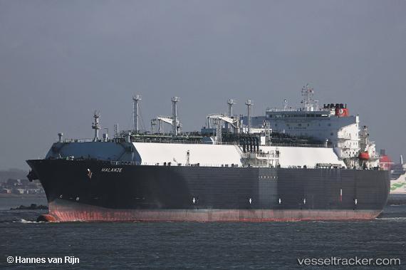
.
Vessel photo of Malanje (IMO 9490959) vesseltracker.com

BS flag Malanje

Vessel type: Lng Tanker | IMO: 9490959 | MMSI: MMSI: 311038600
Call sign: C6YZ2 | Dimensions: 285 m x 44 m
Current Status

Where is the vessel?

Malanje is currently in 212 nm W of Armenia, based on AIS data received less than 1h ago.

Latest AIS update:

Current position: 14.76500° N, 85.99500° E (212 nm W of Armenia)

Average speed (last 7 days): Loading…

Average speed (last 30 days): Loading…

Vessel profile: Malanje is a Lng Tanker with dimensions 285m x 44m.

This page combines live AIS, route history, probable destination signals, nearby traffic, and port activity for practical vessel monitoring.

The current position of vessel Malanje is 14.76500 lat / 85.99500 lng. Updated: 2026-04-03 05:54:27 UTC

Currently sailing under the flag of Bahamas BS flag

Malanje built in 2011 year

Deadweight:
82728 t

Details:

Live Vessel Malanje Analytics (details, animations, etc.)


Recent AIS points (UTC):
2026-04-03 00:12:26 UTC · 16.41167, 86.36833 · SOG 17 kn · COG -1°
2026-04-03 01:15:22 UTC · 16.10667, 86.29500 · SOG 17 kn · COG -1°
2026-04-03 03:30:24 UTC · 15.45167, 86.14333 · SOG 17 kn · COG -1°
2026-04-03 05:54:27 UTC · 14.76500, 85.99500 · SOG 16 kn · COG -1°

Track of the vessel in the last 60 days


UTC: --
Start: -- Track timeline (UTC) End: --
Encountered: --


Link to the map:


Find another ship

Malanje (311038600) last ports (portcalls and passsages)

Sazaire Terminal | 2025-09-04 11:34:09
Assaluyeh | 2025-08-16 20:06:27
AL KHIRAN | 2025-08-14 21:32:23
SOYO | 2025-07-27 08:28:20
DAHEJ | 2025-06-21 17:07:34
Banana | 2025-05-30 08:22:04
SOYO | 2025-05-30 06:48:59
Brixham | 2025-05-12 08:32:12
SOYO | 2025-04-21 13:02:36
MONTOIR | 2025-03-13 02:22:03
ST NAZAIRE | 2025-03-13 01:37:06
SOYO | 2025-02-23 08:15:33
Dover | 2025-02-04 07:37:54
BRIELLE | 2025-02-02 21:59:55
Brixham | 2025-02-01 16:48:28
SOYO | 2025-01-19 07:19:50
TORQUAY | 2024-12-20 23:32:52
BRIELLE | 2024-12-18 22:24:34
Brixham | 2024-12-17 17:29:39
SOYO | 2024-12-05 07:10:35
CORUNA | 2024-11-15 13:35:19
PUNTA LANGOSTEIRA | 2024-11-15 12:25:19
Banana | 2024-10-31 07:24:59
Banana | 2024-09-21 07:11:42
Cochin | 2024-09-01 01:06:27
Banana | 2024-08-15 07:31:16
Mina Saud | 2024-07-24 22:24:39
Banana | 2024-07-05 07:26:59
Banana | 2024-05-24 07:39:36
Banana | 2024-04-05 07:11:26
Singapore | 2024-02-20 02:48:41
Map Ta Phut | 2024-02-17 00:06:05
Banana | 2024-01-23 08:01:01
Banana | 2023-12-03 07:42:12
Durban | 2023-11-11 05:08:40
Banana | 2023-10-11 08:29:56
Brixham | 2023-09-11 01:13:38
Dartmouth | 2023-09-06 08:21:38
Banana | 2023-08-21 08:39:51
St. Nazaire | 2023-07-30 12:27:07
Banana | 2023-07-17 07:42:49
Boma | 2023-07-04 07:08:46
Banana | 2023-07-02 08:18:17
Brixham | 2023-06-03 03:30:35
Brixham | 2023-05-28 07:25:48
Boma | 2023-05-17 06:34:39
Banana | 2023-05-15 08:27:25
Brixham | 2023-04-26 07:52:26
Banana | 2023-04-14 09:23:23
Boma | 2023-04-14 08:25:40
Puerto De La Luz | 2023-04-02 07:27:06
Sheerness | 2023-03-27 02:10:52
Banana | 2023-03-12 08:49:43
Strait Of Gibraltar | 2023-02-08 17:51:38
Algeciras | 2023-02-07 21:27:16
Banana | 2023-01-09 08:49:58
Banana | 2022-11-30 08:21:36
Algeciras | 2022-10-20 07:47:39
Strait Of Gibraltar | 2022-10-20 04:35:03
Brixham | 2022-09-21 07:54:43
Banana | 2022-09-04 10:16:14
Porto Grande | 2022-07-22 16:05:41
Huelva | 2022-07-17 04:40:23
Cartagena | 2022-06-25 04:08:02
Boma | 2022-05-04 07:27:41
Banana | 2022-05-02 12:52:09
Milford Haven | 2022-04-03 21:40:42
Banana | 2022-03-22 08:58:07
Milford Haven | 2022-02-27 18:15:09
Banana | 2022-01-28 10:33:04
Boma | 2022-01-28 08:03:23
Strait Of Gibraltar | 2022-01-16 01:50:07
Algeciras | 2022-01-15 08:40:06
Strait Of Gibraltar | 2022-01-12 11:40:31
Calais | 2022-01-03 15:05:05
Boma | 2021-12-23 15:33:43
Boma | 2021-12-23 15:09:27
Banana | 2021-12-22 08:22:12
Boma | 2021-12-22 07:21:53