 vesseltracker.com
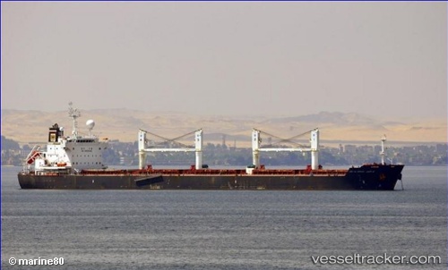
 Abu Al Abyad
Current Status
Where is the vessel?
Abu Al Abyad is currently in 29 nm W of TAEAN-GUN, based on AIS data received about 3h ago.
Latest AIS update:
Current position: 36.89559° N, 125.62710° E (29 nm W of TAEAN-GUN)
Average speed (last 7 days): Loading…
Average speed (last 30 days): Loading…
Vessel profile: Abu Al Abyad is a Bulk Carrier with dimensions 190m x 32m.
This page combines live AIS, route history, probable destination signals, nearby traffic, and port activity for practical vessel monitoring.
The current position of vessel Abu Al Abyad is 36.89559 lat / 125.62710 lng. Updated: 2026-03-26 07:53:45 UTCNearest reference points:
- 49 nm SW of Yeonpyeongdo
- 54 nm W of Taean-gun
- Near Taean-gun
Currently sailing under the flag of Liberia ![]()
Abu Al Abyad built in 2011 year
Deadweight:
57369 tDetails:
Live Vessel Abu Al Abyad Analytics (details, animations, etc.)
Recent AIS points (UTC):
2026-03-26 01:50:00 UTC · 36.91220, 125.57475 · SOG 0.4 kn · COG 167°2026-03-26 04:06:14 UTC · 36.92018, 125.57066 · SOG 0.2 kn · COG 130°
2026-03-26 05:21:06 UTC · 36.91715, 125.58000 · SOG 0.5 kn · COG 160°
2026-03-26 07:53:45 UTC · 36.89559, 125.62710 · SOG 1.2 kn · COG -1°