 vesseltracker.com
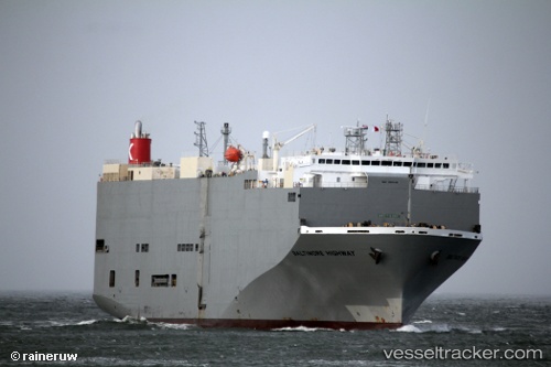
 Baltimore Highway
Current Status
Where is the vessel?
Baltimore Highway is currently in 21 nm SW of San Gregorio, based on AIS data received about 2h ago.
Latest AIS update:
Current position: 37.10700° N, 122.74091° W (21 nm SW of San Gregorio)
Average speed (last 7 days): Loading…
Average speed (last 30 days): Loading…
Vessel profile: Baltimore Highway is a Vehicles Carrier with dimensions 180m x 32m.
This page combines live AIS, route history, probable destination signals, nearby traffic, and port activity for practical vessel monitoring.
The current position of vessel Baltimore Highway is 37.10700 lat / -122.74091 lng. Updated: 2026-03-28 00:11:09 UTCNearest reference points:
- Near San Francisco
- Near Oakland
- Near Treasure Island/Los Angeles
Currently sailing under the flag of Panama ![]()
Baltimore Highway built in 2009 year
Deadweight:
15341 tDetails:
Live Vessel Baltimore Highway Analytics (details, animations, etc.)
Recent AIS points (UTC):
2026-03-27 17:30:09 UTC · 37.16200, -122.55664 · SOG 1.3 kn · COG 242°2026-03-27 19:38:27 UTC · 37.17631, -122.70155 · SOG 10 kn · COG 285°
2026-03-27 21:39:28 UTC · 37.16424, -122.76288 · SOG 1.3 kn · COG 42°
2026-03-28 00:11:09 UTC · 37.10700, -122.74091 · SOG 1.4 kn · COG 44°