 vesseltracker.com
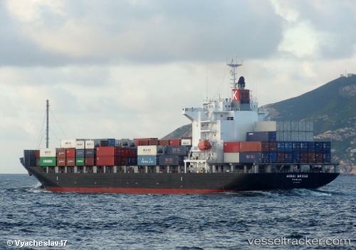
 Horai Bridge
Current Status
Where is the vessel?
Horai Bridge is currently in Near Naka-Ku, Kanagawa, based on AIS data received less than 1h ago.
Latest AIS update:
Current position: 35.39463° N, 139.69768° E (Near Naka-Ku, Kanagawa)
Average speed (last 7 days): Loading…
Average speed (last 30 days): Loading…
Vessel profile: Horai Bridge is a Container Ship with dimensions 172m x 28m.
This page combines live AIS, route history, probable destination signals, nearby traffic, and port activity for practical vessel monitoring.
The current position of vessel Horai Bridge is 35.39463 lat / 139.69768 lng. Updated: 2026-04-02 11:21:19 UTCNearest reference points:
- Near Naka-Ku, Kanagawa
- Near Yokohama
- Near Yokosuka
Currently sailing under the flag of Panama ![]()
Horai Bridge built in 2009 year
Deadweight:
21922 tDetails:
Live Vessel Horai Bridge Analytics (details, animations, etc.)
Recent AIS points (UTC):
2026-04-02 06:13:44 UTC · 35.60327, 139.78552 · SOG 0 kn · COG 328°2026-04-02 07:55:21 UTC · 35.56710, 139.81557 · SOG 9.9 kn · COG 131°
2026-04-02 10:09:18 UTC · 35.39453, 139.69792 · SOG 0.3 kn · COG 12°
2026-04-02 11:21:19 UTC · 35.39463, 139.69768 · SOG 0.1 kn · COG 14°