 vesseltracker.com
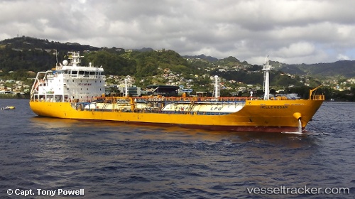
 SAINT JAMES LG
Current Status
Where is the vessel?
SAINT JAMES LG is currently in Near Castries, based on AIS data received less than 1h ago.
Latest AIS update:
Current position: 14.05167° N, 61.00833° W (Near Castries)
Average speed (last 7 days): Loading…
Average speed (last 30 days): Loading…
Vessel profile: SAINT JAMES LG is a Lpg Tanker with dimensions m x m.
This page combines live AIS, route history, probable destination signals, nearby traffic, and port activity for practical vessel monitoring.
The current position of vessel SAINT JAMES LG is 14.05167 lat / -61.00833 lng. Updated: 2026-03-31 03:45:39 UTCNearest reference points:
- Near Gros Islet
- Near LE MARIN
- Near Fort De France
Currently sailing under the flag of Malta ![]()
Details:
Live Vessel SAINT JAMES LG Analytics (details, animations, etc.)
Recent AIS points (UTC):
2026-03-30 21:26:05 UTC · 14.05047, -61.01066 · SOG 0 kn · COG 44°2026-03-31 00:05:09 UTC · 14.05049, -61.01066 · SOG 0 kn · COG 50°
2026-03-31 02:21:38 UTC · 14.05167, -61.00833 · SOG 0 kn · COG -1°
2026-03-31 03:45:39 UTC · 14.05167, -61.00833 · SOG 0 kn · COG -1°