 vesseltracker.com
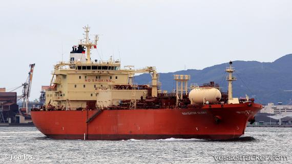
Navigator Glory
Current StatusWhere is the vessel?
Navigator Glory is currently in 98 nm NE of Pagerungan, based on AIS data received about 3h ago.
Latest AIS update:
Current position: 5.53322° S, 116.79235° E (98 nm NE of Pagerungan)
Average speed (last 7 days): Loading…
Average speed (last 30 days): Loading…
Vessel profile: Navigator Glory is a Lpg Tanker with dimensions 25m x 154m.
This page combines live AIS, route history, probable destination signals, nearby traffic, and port activity for practical vessel monitoring.
The current position of vessel Navigator Glory is -5.53322 lat / 116.79235 lng. Updated: 2026-04-13 01:10:26 UTCNearest reference points:
- 74 nm NE of Pagerungan
- 117 nm W of Panakukang
- 70 nm S of MEKAR PUTIH
Details:
Live Vessel Navigator Glory Analytics (details, animations, etc.)
Recent AIS points (UTC):
2026-04-12 17:26:46 UTC · -5.03899, 115.20065 · SOG 13.7 kn · COG 104°2026-04-12 20:20:05 UTC · -5.33504, 115.77641 · SOG 13.1 kn · COG 101°
2026-04-12 23:55:59 UTC · -5.52318, 116.53332 · SOG 12.8 kn · COG 100°
2026-04-13 01:10:26 UTC · -5.53322, 116.79235 · SOG 12.8 kn · COG 74°