 vesseltracker.com
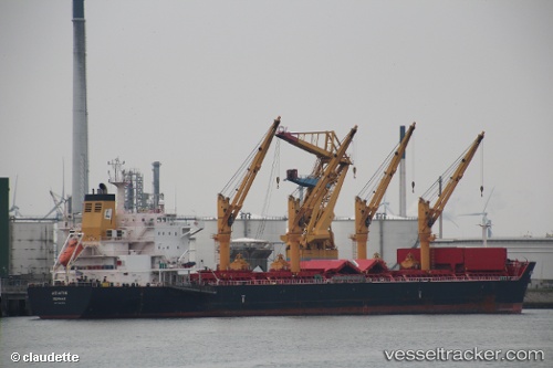
 MAKRA
MAKRA
Current Status
Where is the vessel?
MAKRA is currently in Near Mersin-Free Zone, based on AIS data received about 2h ago.
Latest AIS update:
Current position: 36.79990° N, 34.64913° E (Near Mersin-Free Zone)
Average speed (last 7 days): Loading…
Average speed (last 30 days): Loading…
Vessel profile: MAKRA is a Bulk Carrier with dimensions 196m x 32m.
This page combines live AIS, route history, probable destination signals, nearby traffic, and port activity for practical vessel monitoring.
The current position of vessel MAKRA is 36.79990 lat / 34.64913 lng. Updated: 2026-04-01 15:37:23 UTCNearest reference points:
- Near Mersin-Free Zone
- Near Mersin
- Near YUMURTALIC
Currently sailing under the flag of Bahamas ![]()
MAKRA built in 2012 year
Deadweight:
58451 tDetails:
Live Vessel MAKRA Analytics (details, animations, etc.)
Recent AIS points (UTC):
2026-04-01 10:08:52 UTC · 36.79975, 34.64932 · SOG 0 kn · COG 358°2026-04-01 12:14:59 UTC · 36.79972, 34.64937 · SOG 0 kn · COG 358°
2026-04-01 14:04:30 UTC · 36.79965, 34.64925 · SOG 0 kn · COG -1°
2026-04-01 15:37:23 UTC · 36.79990, 34.64913 · SOG 0 kn · COG 358°