 vesseltracker.com
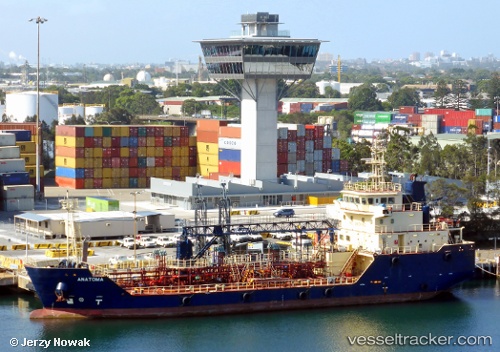
 KORIMAKO
Current Status
Where is the vessel?
KORIMAKO is currently in Near Mount Maunganui, based on AIS data received less than 1h ago.
Latest AIS update:
Current position: 37.64878° S, 176.18285° E (Near Mount Maunganui)
Average speed (last 7 days): Loading…
Average speed (last 30 days): Loading…
Vessel profile: KORIMAKO is a Bunkering Tanker with dimensions 13m x 65m.
This page combines live AIS, route history, probable destination signals, nearby traffic, and port activity for practical vessel monitoring.
The current position of vessel KORIMAKO is -37.64878 lat / 176.18285 lng. Updated: 2026-03-31 00:14:39 UTCNearest reference points:
- Near WHITIANGA
- Near ORAKEI
- Near Matiatia Bay
Currently sailing under the flag of New Zealand ![]()
KORIMAKO built in 2012 year
Deadweight:
1422 tDetails:
Live Vessel KORIMAKO Analytics (details, animations, etc.)
Recent AIS points (UTC):
2026-03-30 17:32:25 UTC · -37.64874, 176.18288 · SOG 0 kn · COG 170°2026-03-30 20:12:28 UTC · -37.65924, 176.18085 · SOG 0 kn · COG 188°
2026-03-30 22:18:26 UTC · -37.65922, 176.18079 · SOG 0 kn · COG 187°
2026-03-31 00:14:39 UTC · -37.64878, 176.18285 · SOG 0 kn · COG 170°