 vesseltracker.com
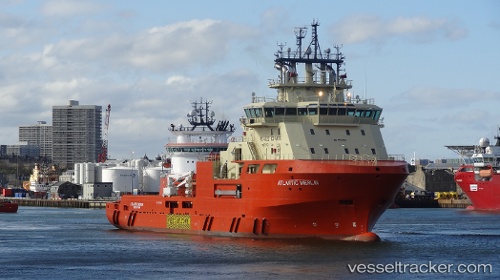
 ATLANTIC MERLIN
Current Status
Where is the vessel?
ATLANTIC MERLIN is currently in 33 nm W of White Rose Field, based on AIS data received about 2h ago.
Latest AIS update:
Current position: 46.75457° N, 48.80823° W (33 nm W of White Rose Field)
Average speed (last 7 days): Loading…
Average speed (last 30 days): Loading…
Vessel profile: ATLANTIC MERLIN is a Offshore Tug/Supply Ship with dimensions m x m.
This page combines live AIS, route history, probable destination signals, nearby traffic, and port activity for practical vessel monitoring.
The current position of vessel ATLANTIC MERLIN is 46.75457 lat / -48.80823 lng. Updated: 2026-04-12 17:33:19 UTCNearest reference points:
- 24 nm SW of White Rose Field
Currently sailing under the flag of Canada ![]()
ATLANTIC MERLIN built in 2014 year
Deadweight:
4500 tDetails:
Live Vessel ATLANTIC MERLIN Analytics (details, animations, etc.)
Recent AIS points (UTC):
2026-04-12 10:29:00 UTC · 46.75126, -48.78243 · SOG 1.2 kn · COG 36°2026-04-12 13:34:59 UTC · 46.75124, -48.78244 · SOG 0.7 kn · COG 36°
2026-04-12 15:31:40 UTC · 46.77457, -48.78455 · SOG 2.5 kn · COG 233°
2026-04-12 17:33:19 UTC · 46.75457, -48.80823 · SOG 3.9 kn · COG 59°