 vesseltracker.com
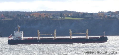
 ANGELINA THE GREAT N
Current Status
Where is the vessel?
ANGELINA THE GREAT N is currently in 35 nm SE of CARBONERAS, based on AIS data received about 1h ago.
Latest AIS update:
Current position: 36.51025° N, 1.46901° W (35 nm SE of CARBONERAS)
Average speed (last 7 days): Loading…
Average speed (last 30 days): Loading…
Vessel profile: ANGELINA THE GREAT N is a Bulk Carrier with dimensions m x m.
This page combines live AIS, route history, probable destination signals, nearby traffic, and port activity for practical vessel monitoring.
The current position of vessel ANGELINA THE GREAT N is 36.51025 lat / -1.46901 lng. Updated: 2026-04-02 11:22:14 UTCNearest reference points:
- 20 nm SE of CARBONERAS
- 47 nm SE of CARBONERAS
- 45 nm N of Mers El Kebir
Currently sailing under the flag of Marshall Islands ![]()
Details:
Live Vessel ANGELINA THE GREAT N Analytics (details, animations, etc.)
Recent AIS points (UTC):
2026-04-02 05:46:33 UTC · 36.29714, -2.82326 · SOG 12 kn · COG 79°2026-04-02 08:01:37 UTC · 36.34647, -2.27458 · SOG 11.7 kn · COG 83°
2026-04-02 10:08:54 UTC · 36.45562, -1.75960 · SOG 11.9 kn · COG 76°
2026-04-02 11:22:14 UTC · 36.51025, -1.46901 · SOG 11.8 kn · COG -1°