 vesseltracker.com
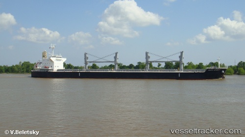
 KRAIT
KRAIT
Current Status
Where is the vessel?
KRAIT is currently in Near Acajutla, based on AIS data received about 2h ago.
Latest AIS update:
Current position: 13.57586° N, 89.83882° W (Near Acajutla)
Average speed (last 7 days): Loading…
Average speed (last 30 days): Loading…
Vessel profile: KRAIT is a Cargo with dimensions m x m.
This page combines live AIS, route history, probable destination signals, nearby traffic, and port activity for practical vessel monitoring.
The current position of vessel KRAIT is 13.57586 lat / -89.83882 lng. Updated: 2026-03-29 11:47:23 UTCNearest reference points:
- Near San Jose
- Near El Salvador
- 14 nm NW of Puerto Cortes
Currently sailing under the flag of Marshall Islands ![]()
Details:
Live Vessel KRAIT Analytics (details, animations, etc.)
Recent AIS points (UTC):
2026-03-29 06:17:24 UTC · 13.57591, -89.83880 · SOG 0.1 kn · COG 126°2026-03-29 07:20:24 UTC · 13.57592, -89.83878 · SOG 0 kn · COG 126°
2026-03-29 09:59:24 UTC · 13.57591, -89.83879 · SOG 0 kn · COG 126°
2026-03-29 11:47:23 UTC · 13.57586, -89.83882 · SOG 0.1 kn · COG 126°