 vesseltracker.com
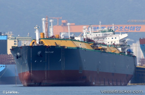
 Palu Lng
Current Status
Where is the vessel?
Palu Lng is currently in 22 nm SE of Sabine Pass, based on AIS data received about 20h ago.
Latest AIS update:
Current position: 29.43333° N, 93.64804° W (22 nm SE of Sabine Pass)
Average speed (last 7 days): Loading…
Average speed (last 30 days): Loading…
Vessel profile: Palu Lng is a Lng Tanker with dimensions 294m x 44m.
This page combines live AIS, route history, probable destination signals, nearby traffic, and port activity for practical vessel monitoring.
The current position of vessel Palu Lng is 29.43333 lat / -93.64804 lng. Updated: 2026-04-10 07:56:02 UTCNearest reference points:
- 23 nm SW of Sabine Pass
- Near SABINE PASS
- 10 nm W of Sabine Pass
Currently sailing under the flag of Malta ![]()
Details:
Live Vessel Palu Lng Analytics (details, animations, etc.)
Recent AIS points (UTC):
2026-04-10 02:38:01 UTC · 29.43359, -93.64799 · SOG 0 kn · COG 105°2026-04-10 04:23:03 UTC · 29.43352, -93.64802 · SOG 0 kn · COG 104°
2026-04-10 05:29:04 UTC · 29.43333, -93.64799 · SOG 0 kn · COG 101°
2026-04-10 07:56:02 UTC · 29.43333, -93.64804 · SOG 0 kn · COG 102°