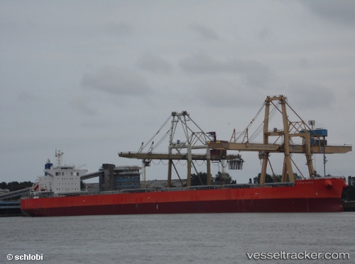
.
Vessel photo of Cetus Ocean (IMO 9643154) vesseltracker.com

PA flag Cetus Ocean

Vessel type: Bulk Carrier | IMO: 9643154 | MMSI: MMSI: 374366000
Call sign: 3EIA8 | Dimensions: 229 m x 229 m
Current Status

Where is the vessel?

Cetus Ocean is currently in 49 nm SE of Terempa, based on AIS data received about 1h ago.

Latest AIS update:

Current position: 2.85674° N, 106.94867° E (49 nm SE of Terempa)

Average speed (last 7 days): Loading…

Average speed (last 30 days): Loading…

Vessel profile: Cetus Ocean is a Bulk Carrier with dimensions 229m x 229m.

This page combines live AIS, route history, probable destination signals, nearby traffic, and port activity for practical vessel monitoring.

The current position of vessel Cetus Ocean is 2.85674 lat / 106.94867 lng. Updated: 2026-03-29 19:48:35 UTC
Nearest reference points:
  • 45 nm E of Terempa
  • 30 nm SW of Belanak Terminal
  • 39 nm SE of Belida Terminal

Currently sailing under the flag of Panama PA flag

Cetus Ocean built in 2013 year

Deadweight:
82986 t

Details:

Live Vessel Cetus Ocean Analytics (details, animations, etc.)


Recent AIS points (UTC):
2026-03-29 13:24:42 UTC · 4.17557, 107.32434 · SOG 13 kn · COG -1°
2026-03-29 14:50:33 UTC · 3.88115, 107.22347 · SOG 12.8 kn · COG -1°
2026-03-29 17:26:54 UTC · 3.33995, 107.08145 · SOG 12.7 kn · COG 197°
2026-03-29 19:48:35 UTC · 2.85674, 106.94867 · SOG 12.7 kn · COG -1°

Track of the vessel in the last 28 days


UTC: --
Start: -- Track timeline (UTC) End: --
Encountered: --


Link to the map:


Find another ship

Cetus_Ocean (374366000) last ports (portcalls and passsages)

GLADSTONE | 2025-08-23 05:36:35
Kobe | 2025-07-28 09:58:57
KADA | 2025-07-28 07:14:45
Newcastle | 2025-07-12 10:20:36
SUMOTO | 2025-06-06 12:23:13
Amagasaki | 2025-06-04 01:58:14
Kobe | 2025-06-04 00:00:46
HON GAI | 2025-05-10 14:12:03
Vung Tau | 2025-05-07 06:29:59
Cai Mep | 2025-05-05 09:37:35
Cai Mep | 2025-05-01 09:35:28
Gemalink | 2025-05-01 09:23:25
Vung Tau | 2025-05-01 08:15:45
Port Kembla | 2025-04-04 18:12:01
Xiamen | 2025-02-19 10:24:05
ZHANGZHOU | 2025-02-19 08:30:46
Newcastle | 2025-01-26 16:17:33
DUNG QUAT | 2025-01-01 20:58:44
Dung Quat Petroleum Port | 2024-12-30 08:18:41
DUNG QUAT | 2024-12-28 20:12:57
DUNG QUAT | 2024-12-24 19:04:11
Dung Quat Petroleum Port | 2024-12-24 17:17:30
GLADSTONE | 2024-12-05 12:51:37
TAKAHAMA | 2024-11-21 08:50:24
OKAMURA | 2024-11-21 07:21:20
Imabari | 2024-11-21 06:27:05
OKAMURA | 2024-11-16 01:21:09
Dung Quat Petroleum Port | 2024-10-23 04:02:42
Zamboanga | 2024-10-18 09:47:17
Gladstone Harbor | 2024-10-04 21:38:13
Thursday Island | 2024-09-25 12:36:49
Torres Strait | 2024-09-25 12:10:47
Thursday Island | 2024-08-09 07:18:53
Thursday Island | 2024-06-25 14:32:29
Torres Strait | 2024-06-25 13:42:11
Yampi Sound | 2024-05-27 11:04:08
Dung Quat Petroleum Port | 2024-04-15 00:25:32
Zamboanga | 2024-04-10 08:15:45
HITACHINAKA | 2024-03-11 22:00:26
Dung Quat Petroleum Port | 2024-01-28 22:23:24
Dung Quat Petroleum Port | 2024-01-24 22:21:25
Cairns Harbor | 2023-12-14 05:46:59
Dung Quat Petroleum Port | 2023-11-24 19:32:08
Dung Quat Petroleum Port | 2023-11-20 03:40:05
Gladstone Harbor | 2023-11-03 22:08:21
Thursday Island | 2023-10-27 12:24:34
Newcastle | 2023-07-31 14:16:16
Tatibana Ko | 2023-07-02 23:14:25
Zamboanga | 2023-04-13 10:56:28
Port Kembla | 2023-03-27 01:31:46
Kobe | 2023-02-14 09:12:19
Kobe | 2023-02-10 08:44:48
Gladstone Harbor | 2022-08-26 22:08:59
Thursday Island | 2022-08-20 07:34:38
Port Darwin | 2022-07-29 04:49:48
Port Darwin | 2022-07-25 04:45:52
Gladstone Harbor | 2022-06-13 07:23:44
Gladstone Harbor | 2022-03-27 06:00:00
Torres Strait | 2022-03-16 09:58:33
Gladstone Harbor | 2022-02-10 06:45:13
Torres Strait | 2022-02-01 08:06:23
Gladstone Harbor | 2021-12-27 12:56:21