 vesseltracker.com
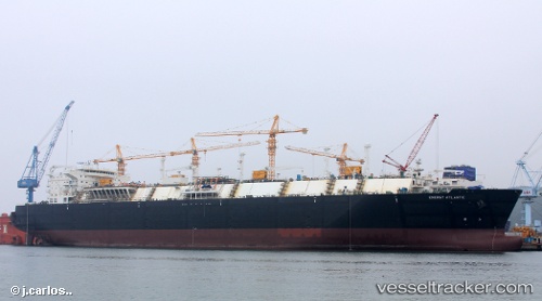
 Energy Atlantic
Current Status
Where is the vessel?
Energy Atlantic is currently in 374 nm SW of Veraval, based on AIS data received about 1h ago.
Latest AIS update:
Current position: 16.79014° N, 65.41746° E (374 nm SW of Veraval)
Average speed (last 7 days): Loading…
Average speed (last 30 days): Loading…
Vessel profile: Energy Atlantic is a Lng Tanker with dimensions 290m x 290m.
This page combines live AIS, route history, probable destination signals, nearby traffic, and port activity for practical vessel monitoring.
The current position of vessel Energy Atlantic is 16.79014 lat / 65.41746 lng. Updated: 2026-03-28 09:25:18 UTCNearest reference points:
- Open sea, approx. 400 nm off the nearest listed port
- Open sea, approx. 404 nm off the nearest listed port
- Open sea, approx. 401 nm off the nearest listed port
Currently sailing under the flag of Malta ![]()
Details:
Live Vessel Energy Atlantic Analytics (details, animations, etc.)
Recent AIS points (UTC):
2026-03-28 04:10:08 UTC · 17.92364, 64.30144 · SOG 17.4 kn · COG -1°2026-03-28 05:38:25 UTC · 17.61659, 64.61335 · SOG 17.4 kn · COG 138°
2026-03-28 07:12:48 UTC · 17.26440, 64.93492 · SOG 18.1 kn · COG 138°
2026-03-28 09:25:18 UTC · 16.79014, 65.41746 · SOG 17.3 kn · COG 143°