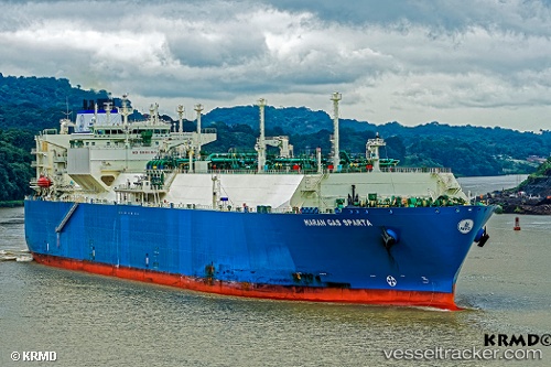
.
Vessel photo of Maran Gas Sparta (IMO 9650042) vesseltracker.com

GR flag Maran Gas Sparta

Vessel type: Lng Tanker | IMO: 9650042 | MMSI: MMSI: 241289000
Call sign: SVBW4 | Dimensions: 289 m x 45 m
Current Status

Where is the vessel?

Maran Gas Sparta is currently in 105 nm W of Salomague, based on AIS data received about 1h ago.

Latest AIS update:

Current position: 18.22273° N, 118.63516° E (105 nm W of Salomague)

Average speed (last 7 days): Loading…

Average speed (last 30 days): Loading…

Vessel profile: Maran Gas Sparta is a Lng Tanker with dimensions 289m x 45m.

This page combines live AIS, route history, probable destination signals, nearby traffic, and port activity for practical vessel monitoring.

The current position of vessel Maran Gas Sparta is 18.22273 lat / 118.63516 lng. Updated: 2026-03-26 06:16:36 UTC
Nearest reference points:
  • 138 nm NW of Bolinao
  • 22 nm W of Salomague
  • 132 nm SW of Kaohsiung

Currently sailing under the flag of Greece GR flag

Details:

Live Vessel Maran Gas Sparta Analytics (details, animations, etc.)


Recent AIS points (UTC):
2026-03-26 00:19:08 UTC · 17.07131, 117.64984 · SOG 15.4 kn · COG 27°
2026-03-26 01:19:08 UTC · 17.25969, 117.82517 · SOG 14.9 kn · COG 41°
2026-03-26 03:26:18 UTC · 17.66371, 118.16454 · SOG 14.8 kn · COG 38°
2026-03-26 06:16:36 UTC · 18.22273, 118.63516 · SOG 15.1 kn · COG 40°

Track of the vessel in the last 28 days


UTC: --
Start: -- Track timeline (UTC) End: --
Encountered: --


Link to the map:


Find another ship

Maran_Gas_Sparta (241289000) last ports (portcalls and passsages)

BINTULU | 2025-08-18 02:26:42
PYEONGTAEK | 2025-07-05 01:39:24
DAESAN | 2025-07-04 23:48:16
BINTULU | 2025-06-26 23:01:49
Map Ta Phut | 2025-06-21 23:22:00
BINTULU | 2025-06-15 21:09:46
PENGERANG | 2025-06-10 05:20:12
PULAU SAMBU | 2025-06-10 03:20:43
JURONG ISLAND | 2025-06-07 04:15:33
BUKOM ISLAND | 2025-06-06 08:49:15
JURONG ISLAND | 2025-06-03 02:51:57
JURONG ISLAND | 2025-05-30 02:31:26
JURONG ISLAND | 2025-05-26 01:54:37
JURONG ISLAND | 2025-05-22 00:59:56
JURONG ISLAND | 2025-05-18 00:48:46
BUKOM ISLAND | 2025-05-17 05:24:28
PULAU SAMBU | 2025-05-17 05:05:02
BATU AMPAR | 2025-05-17 04:02:29
PENGERANG | 2025-05-17 02:22:14
Yokohama | 2025-05-06 05:51:56
KIMITSU | 2025-05-05 02:01:06
Malabo | 2025-04-07 04:19:28
Strait Of Gibraltar | 2025-03-22 11:22:08
TARIFA | 2025-03-22 09:27:03
SOUVALA | 2025-03-13 12:23:09
VOULA | 2025-03-13 01:50:23
KITHIRA | 2025-03-08 12:38:40
Setubal | 2025-02-06 14:44:58
SAINT LOUIS DU RHONE | 2025-01-31 10:24:28
LAVERA | 2025-01-29 10:02:34
TARIFA | 2025-01-19 20:10:13
SABINE PASS | 2024-12-23 07:44:17
SABINE PASS | 2024-11-23 14:35:23
Zeebrugge | 2024-11-06 05:39:34
Porto Grande | 2024-10-16 06:02:25
Das Island | 2024-02-24 19:09:20
Port Louis | 2024-01-22 03:51:35
Zeebrugge | 2023-12-08 13:31:30
Zeebrugge | 2023-11-08 05:17:19
Port Louis | 2023-09-28 01:11:29
Sambu | 2023-06-19 04:00:22
Sambu | 2023-06-12 22:39:25
Singapore | 2023-05-17 03:10:34
Port Darwin | 2023-03-18 23:52:41
Sambu | 2023-03-09 09:12:48
Singapore | 2023-03-07 23:42:42
Sambu | 2022-12-18 11:37:39
Sirri Island | 2022-12-06 03:05:59
Sirri Island | 2022-10-16 07:13:40
Cochin | 2022-09-04 04:10:11
Sirri Island | 2022-08-29 19:02:46
Mina Saud | 2022-08-10 22:44:27
Mina Saud | 2022-07-29 04:29:40
Bonny | 2022-06-07 08:09:51
Cape Of Good Hope | 2022-06-01 16:51:38
Singapore | 2022-05-17 22:36:36
Gladstone Harbor | 2022-03-11 12:05:03
Bonny | 2022-01-26 19:42:22
Urdiales | 2022-01-14 07:00:27
Bilbao | 2022-01-14 06:35:37
Urdiales | 2022-01-14 06:35:07
Urdiales | 2022-01-13 09:10:14
Urdiales | 2022-01-13 08:55:45
Malabo | 2021-12-14 05:35:55