 vesseltracker.com
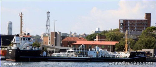
Manning
Current StatusWhere is the vessel?
Manning is currently in Near Waverton, based on AIS data received about 2d ago.
Latest AIS update:
Current position: 33.84174° S, 151.19299° E (Near Waverton)
Average speed (last 7 days): Loading…
Average speed (last 30 days): Loading…
Vessel profile: Manning is a Oil Products Tanker with dimensions 12m x 63m.
This page combines live AIS, route history, probable destination signals, nearby traffic, and port activity for practical vessel monitoring.
The current position of vessel Manning is -33.84174 lat / 151.19299 lng. Updated: 2026-03-24 00:45:00 UTCNearest reference points:
- Near Waverton
- Near Greenwich
- Near DRUMMOYNE SYDNEY
Details:
Live Vessel Manning Analytics (details, animations, etc.)
Recent AIS points (UTC):
2026-03-23 23:38:12 UTC · -33.84176, 151.19305 · SOG 0 kn · COG 51°2026-03-24 00:45:00 UTC · -33.84174, 151.19299 · SOG 0 kn · COG -1°
2026-03-24 00:45:00 UTC · -33.84174, 151.19299 · SOG 0 kn · COG -1°
2026-03-24 00:45:00 UTC · -33.84174, 151.19299 · SOG 0 kn · COG -1°