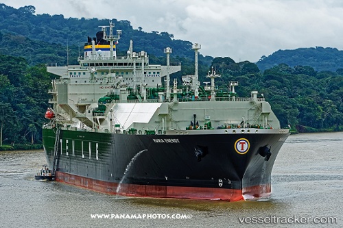
.
Vessel photo of Maria Energy (IMO 9659725) vesseltracker.com

Maria Energy

Vessel type: Lng Tanker | IMO: 9659725 | MMSI: MMSI: 636017445
Call sign: D5KZ6 | Dimensions: 46 m x 289 m
Current Status

Where is the vessel?

Maria Energy is currently in 62 nm S of Jiazi, based on AIS data received about 2h ago.

Latest AIS update:

Current position: 21.83966° N, 115.91854° E (62 nm S of Jiazi)

Average speed (last 7 days): Loading…

Average speed (last 30 days): Loading…

Vessel profile: Maria Energy is a Lng Tanker with dimensions 46m x 289m.

This page combines live AIS, route history, probable destination signals, nearby traffic, and port activity for practical vessel monitoring.

The current position of vessel Maria Energy is 21.83966 lat / 115.91854 lng. Updated: 2026-04-01 15:09:32 UTC
Nearest reference points:
  • 49 nm S of SHANWEI
  • 53 nm S of Jiazi
  • 64 nm SE of Jiazi
Details:

Live Vessel Maria Energy Analytics (details, animations, etc.)


Recent AIS points (UTC):
2026-04-01 09:32:07 UTC · 22.05398, 114.60153 · SOG 13.2 kn · COG 112°
2026-04-01 11:39:37 UTC · 21.95036, 115.08992 · SOG 13.2 kn · COG 109°
2026-04-01 13:46:24 UTC · 21.90996, 115.59609 · SOG 13.2 kn · COG 105°
2026-04-01 15:09:32 UTC · 21.83966, 115.91854 · SOG 13.2 kn · COG 105°

Track of the vessel in the last 60 days


UTC: --
Start: -- Track timeline (UTC) End: --
Encountered: --


Link to the map:


Find another ship

Maria_Energy (636017445) last ports (portcalls and passsages)

GOHYEON | 2025-08-31 04:35:01
ANJEONG | 2025-08-30 00:58:59
BUSAN NEW PORT | 2025-08-29 23:20:06
YANGSHAN | 2025-07-19 09:48:12
BINTULU | 2025-07-12 00:19:12
JURONG ISLAND | 2025-07-02 02:56:37
BUKOM ISLAND | 2025-07-02 00:55:34
TANAH MERAH | 2025-07-01 23:38:22
PENGERANG | 2025-07-01 22:04:07
Yokohama | 2025-06-20 19:58:56
ONSLOW | 2025-06-09 08:18:19
ASHBURTON | 2025-06-08 09:11:53
Selat Lombok | 2025-06-06 07:24:34
Barrow Island | 2025-05-18 15:28:28
Yokohama | 2025-05-08 04:58:27
KIMITSU | 2025-05-06 23:50:28
Yokosuka | 2025-05-06 22:59:31
ONSLOW | 2025-04-27 03:11:54
ASHBURTON | 2025-04-26 01:07:17
NAOETSU | 2025-04-13 23:43:21
ASHBURTON | 2025-03-30 08:31:28
BAKAUHENI | 2025-03-17 12:20:40
Map Ta Phut | 2025-03-11 22:54:54
BINTULU | 2025-03-04 00:09:36
DAECHEONHANG | 2025-02-19 03:19:15
BINTULU | 2025-02-07 01:22:33
BORYEONG | 2025-01-02 02:08:44
DAECHEONHANG | 2025-01-02 00:30:53
Tso-Ying | 2024-11-23 07:36:06
DAECHEONHANG | 2024-11-19 02:18:41
BINTULU | 2024-11-07 22:40:31
Sambu | 2024-11-03 09:59:11
Malabo | 2024-10-06 05:28:38
Singapore | 2024-09-15 04:10:46
Map Ta Phut | 2024-09-11 23:42:16
Yokohama | 2024-08-02 03:59:24
Yokosuka | 2024-08-01 00:56:54
Yokosuka | 2024-05-30 06:59:55
Yokohama | 2024-05-30 06:22:39
Kawasaki | 2024-05-30 06:15:13
Port Darwin | 2024-05-16 22:25:31
Cartagena | 2024-02-26 22:49:27
Strait Of Gibraltar | 2024-02-26 06:41:25
Sheerness | 2024-01-21 05:51:09
Bonny | 2023-12-29 03:25:31
Singapore | 2023-11-26 08:52:19
Bonny | 2023-10-30 01:37:42
Calais | 2023-09-16 06:35:58
La Plata | 2023-08-07 17:24:58
Buenos Aires | 2023-08-05 20:27:20
Salvador | 2023-07-25 09:16:26
La Plata | 2023-06-02 09:47:44
Buenos Aires | 2023-06-02 06:43:21
Milford Haven | 2023-04-21 15:08:03
Livorno | 2023-03-17 11:04:19
Livorno | 2023-03-13 09:01:18
Bonny | 2023-02-17 12:07:34
Algeciras | 2023-01-13 08:30:58
Galveston | 2022-09-02 14:00:53
Grand Banks South | 2022-08-26 04:09:10
Brixham | 2022-08-21 08:05:22
Strait Of Gibraltar | 2022-07-23 16:03:11
Cartagena | 2022-07-22 04:03:22
Port Said | 2022-07-13 16:07:55
Ras Gharib | 2022-06-23 22:37:55
Bur Ibrahim | 2022-06-23 16:52:05
Port Said | 2022-06-23 07:29:22
Canakkale | 2022-05-13 04:54:34
Strait Of Gibraltar | 2022-05-06 13:23:39
Gibraltar | 2022-05-02 12:42:38
Calais | 2022-03-24 06:25:07
Dover | 2021-12-31 21:50:14