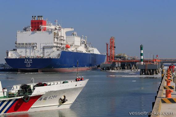
.
Vessel photo of Cesi Beihai (IMO 9672844) vesseltracker.com

HK flag Cesi Beihai

Vessel type: Lng Tanker | IMO: 9672844 | MMSI: MMSI: 477884800
Call sign: VRPI4 | Dimensions: 289 m x 289 m
Current Status

Where is the vessel?

Cesi Beihai is currently in 13 nm S of Tianjin Pt, based on AIS data received about 1h ago.

Latest AIS update:

Current position: 38.76561° N, 117.76636° E (13 nm S of Tianjin Pt)

Average speed (last 7 days): Loading…

Average speed (last 30 days): Loading…

Vessel profile: Cesi Beihai is a Lng Tanker with dimensions 289m x 289m.

This page combines live AIS, route history, probable destination signals, nearby traffic, and port activity for practical vessel monitoring.

The current position of vessel Cesi Beihai is 38.76561 lat / 117.76636 lng. Updated: 2026-03-30 01:29:01 UTC
Nearest reference points:
  • Near Tianjin Pt
  • Near Tianjin Xingang Pt
  • Near Dagu

Currently sailing under the flag of Hong Kong HK flag

Details:

Live Vessel Cesi Beihai Analytics (details, animations, etc.)


Recent AIS points (UTC):
2026-03-29 20:21:41 UTC · 38.65666, 118.76606 · SOG 10.1 kn · COG 268°
2026-03-29 21:54:11 UTC · 38.72377, 118.46420 · SOG 9.5 kn · COG 293°
2026-03-30 00:03:22 UTC · 38.76404, 118.05989 · SOG 9.8 kn · COG 269°
2026-03-30 01:29:01 UTC · 38.76561, 117.76636 · SOG 7.2 kn · COG 270°

Track of the vessel in the last 28 days


UTC: --
Start: -- Track timeline (UTC) End: --
Encountered: --


Link to the map:


Find another ship

Cesi_Beihai (477884800) last ports (portcalls and passsages)

GLADSTONE | 2025-08-28 05:17:50
Busan | 2025-08-13 20:58:43
HOSAN | 2025-08-13 03:27:07
GLADSTONE | 2025-07-28 18:05:02
PENGERANG | 2025-07-17 15:38:15
TANAH MERAH | 2025-07-17 14:53:29
PULAU SAMBU | 2025-07-17 13:46:01
JURONG ISLAND | 2025-07-17 04:03:31
BUKOM ISLAND | 2025-07-14 14:13:08
JURONG ISLAND | 2025-07-13 02:44:27
PULAU SAMBU | 2025-07-13 01:24:38
TANAH MERAH | 2025-07-13 00:27:17
PENGERANG | 2025-07-12 23:24:42
GLADSTONE | 2025-06-24 02:16:20
DONGJIAKOU | 2025-06-09 03:24:35
GLADSTONE | 2025-05-29 04:18:12
GLADSTONE | 2025-05-02 18:47:17
WAILINGDING ISLAND | 2025-04-20 08:55:26
GLADSTONE | 2025-04-06 23:51:50
GLADSTONE | 2025-03-12 02:02:42
GLADSTONE | 2025-02-11 02:32:02
XIANTOULING | 2025-01-24 02:08:56
GLADSTONE | 2025-01-13 02:22:28
WAILINGDING ISLAND | 2024-12-31 04:06:14
GLADSTONE | 2024-12-15 15:27:49
DONGJIAKOU | 2024-12-02 02:22:47
GLADSTONE | 2024-11-19 17:34:29
XIANTOULING | 2024-11-07 02:33:01
Gladstone Harbor | 2024-10-24 21:56:30
Gladstone Harbor | 2024-09-30 13:20:28
Gladstone Harbor | 2024-08-28 12:02:13
Gladstone Harbor | 2024-08-02 02:23:49
Gladstone Harbor | 2024-07-04 14:23:31
Gladstone Harbor | 2024-06-06 02:41:42
Gladstone Harbor | 2024-05-10 03:51:13
Gladstone Harbor | 2024-04-11 04:15:10
Gladstone Harbor | 2024-03-11 20:22:02
Yosu | 2024-02-26 23:49:49
Gladstone Harbor | 2024-02-15 19:10:27
Gladstone Harbor | 2024-01-20 23:36:26
Gladstone Harbor | 2023-12-29 04:21:49
Gladstone Harbor | 2023-11-07 23:26:15
Gladstone Harbor | 2023-10-13 02:22:11
Gladstone Harbor | 2023-09-14 15:22:42
Gladstone Harbor | 2023-08-21 17:52:25
Gladstone Harbor | 2023-07-19 15:49:11
Gladstone Harbor | 2023-06-16 13:32:39
Gladstone Harbor | 2023-05-22 16:27:42
Gladstone Harbor | 2023-04-25 18:38:01
Gladstone Harbor | 2023-03-29 22:02:42
Gladstone Harbor | 2023-02-04 15:04:19
Gladstone Harbor | 2023-01-10 08:40:12
Gladstone Harbor | 2022-12-12 18:03:59
Gladstone Harbor | 2022-10-23 13:06:27
Gladstone Harbor | 2022-09-28 17:01:08
Gladstone Harbor | 2022-09-02 07:44:59
Gladstone Harbor | 2022-07-31 04:11:02
Hong Kong | 2022-05-21 22:38:47
Gladstone Harbor | 2021-12-01 01:50:27