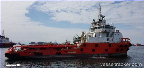
.
Vessel photo of Sk Power (IMO 9690638) vesseltracker.com

Sk Power

Vessel type: Offshore Tug Supply Ship | IMO: 9690638 | MMSI: MMSI: 533180100
Call sign: 9MVA7 | Dimensions: 16 m x 60 m
Current Status

Where is the vessel?

Sk Power is currently in Near PASIR GUDANG, based on AIS data received less than 1h ago.

Latest AIS update:

Current position: 1.45652° N, 103.87406° E (Near PASIR GUDANG)

Average speed (last 7 days): Loading…

Average speed (last 30 days): Loading…

Vessel profile: Sk Power is a Offshore Tug Supply Ship with dimensions 16m x 60m.

This page combines live AIS, route history, probable destination signals, nearby traffic, and port activity for practical vessel monitoring.

The current position of vessel Sk Power is 1.45652 lat / 103.87406 lng. Updated: 2026-04-02 17:23:23 UTC
Nearest reference points:
  • Near PASIR GUDANG
  • Near Johor
  • Near SEMBAWANG
Details:

Live Vessel Sk Power Analytics (details, animations, etc.)


Recent AIS points (UTC):
2026-04-02 11:42:24 UTC · 1.45653, 103.87405 · SOG 0 kn · COG 326°
2026-04-02 13:37:24 UTC · 1.45651, 103.87406 · SOG 0 kn · COG 326°
2026-04-02 15:34:03 UTC · 1.45651, 103.87406 · SOG 0 kn · COG 326°
2026-04-02 17:23:23 UTC · 1.45652, 103.87406 · SOG 0 kn · COG 326°

Track of the vessel in the last 60 days


UTC: --
Start: -- Track timeline (UTC) End: --
Encountered: --


Link to the map:


Find another ship

Sk_Power (533180100) last ports (portcalls and passsages)

SUTERA | 2025-08-12 00:10:26
SUTERA | 2025-07-20 18:59:04
Kota Kinabalu | 2025-07-20 18:10:24
SUTERA | 2025-07-04 23:14:02
LABUAN | 2025-06-29 15:47:46
LABUAN | 2025-06-25 15:43:41
LABUAN | 2025-06-21 14:52:37
LABUAN | 2025-06-17 14:33:09
LABUAN | 2025-06-13 14:24:32
BINTULU | 2025-06-09 23:33:15
BINTULU | 2025-05-28 00:07:47
BINTULU | 2025-05-20 00:56:49
BINTULU | 2025-05-15 01:06:21
BINTULU | 2025-05-08 04:42:35
BINTULU | 2025-05-04 04:41:58
BINTULU | 2025-04-21 01:19:34
BINTULU | 2025-04-16 23:43:43
BINTULU | 2025-04-10 01:23:27
BINTULU | 2025-04-01 22:09:35
BINTULU | 2025-03-24 19:09:24
KEMAMAN | 2025-03-18 03:06:32
KEMAMAN | 2025-03-14 02:05:48
KEMAMAN | 2025-03-10 01:32:57
KEMAMAN | 2025-03-06 01:02:09
KEMAMAN | 2025-03-02 00:48:07
KEMAMAN | 2025-02-25 23:47:19
KEMAMAN | 2025-02-21 23:21:01
KEMAMAN | 2025-02-17 22:51:46
KEMAMAN | 2025-02-13 21:43:28
KEMAMAN | 2025-02-09 21:30:12
KEMAMAN | 2025-02-05 21:21:57
KEMAMAN | 2025-02-01 20:21:33
KEMAMAN | 2025-01-28 20:11:30
SEMBAWANG | 2025-01-27 01:37:56
CHANGI | 2025-01-27 00:22:56
PENGERANG | 2025-01-23 19:47:08
TANAH MERAH | 2025-01-23 18:27:27
PULAU SAMBU | 2025-01-23 17:22:22
Singapore | 2025-01-23 07:34:20
BUKOM ISLAND | 2025-01-22 05:18:49
PULAU SAMBU | 2025-01-19 07:05:29
BUKOM ISLAND | 2025-01-18 02:59:50
JURONG ISLAND | 2025-01-16 10:39:35
JURONG ISLAND | 2025-01-12 10:06:59
JURONG ISLAND | 2025-01-08 09:53:46
JURONG ISLAND | 2025-01-04 08:49:03
JURONG ISLAND | 2024-12-31 07:52:39
JURONG ISLAND | 2024-12-27 07:10:13
JURONG ISLAND | 2024-12-23 05:30:27
JURONG ISLAND | 2024-12-19 05:23:18
JURONG ISLAND | 2024-12-15 04:57:27
JURONG ISLAND | 2024-12-11 04:07:10
JURONG ISLAND | 2024-12-07 03:03:18
JURONG ISLAND | 2024-12-03 02:19:44
JURONG ISLAND | 2024-11-29 00:28:41
JURONG ISLAND | 2024-11-25 00:24:31
BUKOM ISLAND | 2024-11-24 22:05:01
PULAU SAMBU | 2024-11-24 20:59:51
Sambu | 2024-11-24 19:42:45
TANAH MERAH | 2024-11-24 19:27:07
PENGERANG | 2024-11-24 17:09:51
KEMAMAN | 2024-11-20 09:44:04
KEMAMAN | 2024-11-16 09:36:01
KEMAMAN | 2024-11-12 09:28:58
KEMAMAN | 2024-11-08 09:25:41
KEMAMAN | 2024-11-04 09:23:48