 vesseltracker.com
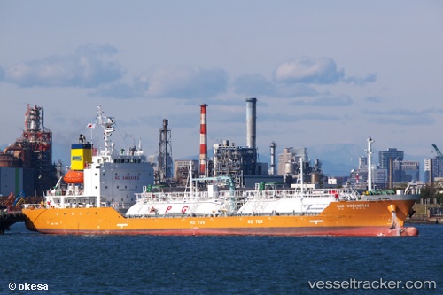
 Gas Oceanroad
Current Status
Where is the vessel?
Gas Oceanroad is currently in Near PORT DICKSON, based on AIS data received about 1h ago.
Latest AIS update:
Current position: 2.51974° N, 101.75472° E (Near PORT DICKSON)
Average speed (last 7 days): Loading…
Average speed (last 30 days): Loading…
Vessel profile: Gas Oceanroad is a Lpg Tanker with dimensions 96m x 15m.
This page combines live AIS, route history, probable destination signals, nearby traffic, and port activity for practical vessel monitoring.
The current position of vessel Gas Oceanroad is 2.51974 lat / 101.75472 lng. Updated: 2026-03-31 21:43:44 UTCNearest reference points:
- Near PORT DICKSON
- Near Sendayan Village
- 13 nm SW of PORT DICKSON
Currently sailing under the flag of Korea ![]()
Details:
Live Vessel Gas Oceanroad Analytics (details, animations, etc.)
Recent AIS points (UTC):
2026-03-31 15:43:43 UTC · 2.52142, 101.75384 · SOG 0 kn · COG 138°2026-03-31 17:58:46 UTC · 2.52151, 101.75406 · SOG 0 kn · COG 149°
2026-03-31 19:40:49 UTC · 2.52149, 101.75431 · SOG 0 kn · COG 161°
2026-03-31 21:43:44 UTC · 2.51974, 101.75472 · SOG 0 kn · COG 346°