 vesseltracker.com
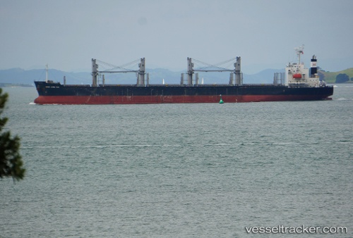
 AMIDALA
Current Status
Where is the vessel?
AMIDALA is currently in Near Robert's Bank, based on AIS data received about 1h ago.
Latest AIS update:
Current position: 49.05553° N, 123.32261° W (Near Robert's Bank)
Average speed (last 7 days): Loading…
Average speed (last 30 days): Loading…
Vessel profile: AMIDALA is a Bulk Carrier with dimensions 30m x 180m.
This page combines live AIS, route history, probable destination signals, nearby traffic, and port activity for practical vessel monitoring.
The current position of vessel AMIDALA is 49.05553 lat / -123.32261 lng. Updated: 2026-04-19 01:52:08 UTCNearest reference points:
- Near Robert's Bank
- Near STEVESTON
- Near English Bay
Currently sailing under the flag of Liberia ![]()
AMIDALA built in 2015 year
Deadweight:
34443 tDetails:
Live Vessel AMIDALA Analytics (details, animations, etc.)
Recent AIS points (UTC):
2026-04-18 20:11:43 UTC · 48.22183, -123.64989 · SOG 11.3 kn · COG 87°2026-04-18 21:56:52 UTC · 48.35457, -123.38264 · SOG 11.1 kn · COG 73°
2026-04-18 23:30:19 UTC · 48.65109, -123.23864 · SOG 14.6 kn · COG 352°
2026-04-19 01:52:08 UTC · 49.05553, -123.32261 · SOG 13.9 kn · COG 320°